Hurricane Easy (1950)
| Category 3 major hurricane (SSHWS/NWS) | |

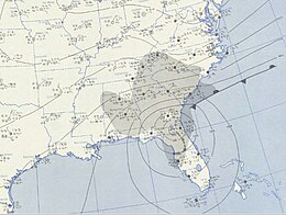
September 7, 1950, weather map featuring Hurricane Easy
|
|
| Formed | September 1, 1950 |
|---|---|
| Dissipated | September 9, 1950 |
| Highest winds |
1-minute sustained: 125 mph (205 km/h) |
| Lowest pressure | 958 mbar (hPa); 28.29 inHg |
| Fatalities | 2 indirect |
| Damage | $3.3 million (1950 USD) |
| Areas affected | Cuba, Florida, Georgia |
| Part of the 1950 Atlantic hurricane season | |
Hurricane Easy was the fifth tropical storm, hurricane, and major hurricane of the 1950 Atlantic hurricane season. The hurricane developed in the western Caribbean Sea on September 1, and tracked northeastward. After crossing Cuba, the hurricane rapidly strengthened in the eastern Gulf of Mexico to reach peak winds of 125 mph (205 km/h). Easy executed a cyclonic loop, moved northeastward to hit near Cedar Key, Florida, executed a second loop, and hit western Florida again. After rapidly weakening over Florida, the hurricane turned to the northwest, and ultimately dissipated over northeastern Arkansas on September 9. From the point when Hurricane Easy entered the Gulf of Mexico until it weakened to a tropical storm, it was observed nearly constantly from radars or Reconnaissance Aircraft.
Easy is the most recent major hurricane to strike the Homosassa, Florida, area. Due to the hurricane remaining near the northwest Florida coast for an extended period of time, Easy produced severe rainfall and strong waves, resulting in heavy damage in the Cedar Key area. Hurricane Easy was one of two major hurricanes to strike Florida during the year; the other was Hurricane King which affected Miami.
Following the passage of Hurricane Baker through the Caribbean Sea, a trough of low pressure persisted across the western Caribbean Sea. On August 31, convection became more concentrated to the south of the Isle of Youth, and on September 1 the disturbance developed into a tropical storm; it was later given the name "Easy", as part of the United States Weather Bureau naming tropical cyclones with the Joint Army/Navy Phonetic Alphabet. A developing anticyclone and moist air over the region provided favorable conditions for intensification, as the storm tracked slowly northeastward. On September 2, Tropical Storm Easy attained hurricane status about 50 miles (85 km) south of the Isle of Youth.
...
Wikipedia
