Cedar Key, Florida
| Cedar Key, Florida | |
|---|---|
| City | |

Aerial view of Cedar Key and its outlying islands, illustrating the extremely small size of the city: The fork at State Roads 24 and 347 (the only two access roads) can be seen in the upper left.
|
|
 Location in Levy County, Florida |
|
| Coordinates: 29°8′44″N 83°2′30″W / 29.14556°N 83.04167°WCoordinates: 29°8′44″N 83°2′30″W / 29.14556°N 83.04167°W | |
| Country |
|
| State |
|
| County | Levy |
| Area | |
| • Total | 2.1 sq mi (5.5 km2) |
| • Land | 1.0 sq mi (2.5 km2) |
| • Water | 1.2 sq mi (3.0 km2) |
| Elevation | 10 ft (3 m) |
| Population (2010) | |
| • Total | 702 |
| • Density | 330/sq mi (130/km2) |
| Time zone | Eastern (EST) (UTC-5) |
| • Summer (DST) | EDT (UTC-4) |
| ZIP code | 32625 |
| Area code(s) | 352 |
| FIPS code | 12-11225 |
| GNIS feature ID | 0280208 |
|
Cedar Keys Historic and Archaeological District
|
|

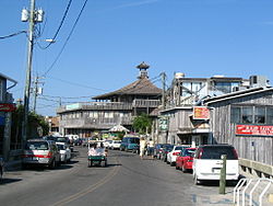
Dock Street in Cedar Key
|
|
| Location | Cedar Key, Florida |
|---|---|
| Coordinates | 29°08′44″N 83°02′30″W / 29.14556°N 83.04167°W |
| NRHP Reference # | 88001449 |
| Added to NRHP | October 3, 1989 |
Cedar Key is a city in Levy County, Florida, United States. The population was 702 at the 2010 census. The Cedar Keys are a cluster of islands near the mainland. Most of the developed area of the city has been on Way Key since the end of the 19th century. The Cedar Keys are named for the eastern red cedar, Juniperus virginiana, once abundant in the area.
While evidence suggests human occupation as far back as 500 BC, the first maps of the area date to 1542, when it was labeled "Las Islas Sabines" by a Spanish cartographer. An archaeological dig at Shell Mound, 9 miles (14 km) north of Cedar Key, found artifacts dating back to 500 BC in the top 10 feet (3.0 m) of the 28-foot-tall (8.5 m) mound. The only ancient burial found in Cedar Key was a 2,000-year-old skeleton found in 1999. Arrow heads and spear points dating from the Paleo period (12,000 years old) were collected by Cedar Key historian St. Clair Whitman and are displayed at the Cedar Key Museum State Park.
Followers of William Augustus Bowles, self-declared "Director General of the State of Muskogee", built a watchtower in the vicinity of Cedar Key in 1801. The tower was destroyed by a Spanish force in 1802. In the period leading up to the First Seminole War, the British subjects Alexander Arbuthnot and Robert Ambrister used the Cedar Keys to deliver supplies to the Seminoles. The Cedar Keys may have been a refuge for escaped slaves in the early 1820s, and an entry point for the illegal slave trade later that decade.
During the Second Seminole War, the United States Army established Fort No. 4 on the mainland adjacent to the Cedar Keys. (The name "No. 4" was later applied to a boat channel next to the fort, and then to a railroad trestle and a highway bridge over that channel.) In 1840, General Zachary Taylor requested the Cedar Keys be reserved for military use for the duration of the war, and that Seahorse Key be permanently reserved for a lighthouse. In 1840, General Walker Keith Armistead, who had succeeded Zachary Taylor as commander of United States troops in the war, ordered construction of a hospital on what had become known as Depot Key. (The island's name may reflect the establishment of a depot there by Florida militia general Leigh Read. The primary depot for the U.S. Army in Florida at the time was at Palatka.) Depot Key was the headquarters for the Army in Florida, but Fishburne states headquarters was not in a fixed place, but wherever the commander was.
...
Wikipedia
