Hurricane King
| Category 4 major hurricane (SSHWS/NWS) | |

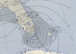
Weather Map featuring Hurricane King making landfall in Florida
|
|
| Formed | October 13, 1950 |
|---|---|
| Dissipated | October 20, 1950 |
| Highest winds |
1-minute sustained: 130 mph (215 km/h) |
| Lowest pressure | 955 mbar (hPa); 28.2 inHg |
| Fatalities | 11 direct |
| Damage | $32 million (1950 USD) |
| Areas affected | Cuba, Florida, Georgia |
| Part of the 1950 Atlantic hurricane season | |
Hurricane King was the most severe hurricane to strike the city of Miami, Florida, since the 1926 Miami hurricane. It was the eleventh tropical storm and the last of six major hurricanes in the 1950 Atlantic hurricane season. The cyclone formed in the western Caribbean Sea on October 13, and initially moved northeastward, slowly strengthening. Hurricane King crossed Cuba on October 17, causing seven deaths and $2 million in damage (1950 USD). It reached its peak intensity of 130 mph (210 km/h) and subsequently made landfall on downtown Miami. The hurricane damaged 20,861 houses in southern Florida, 580 of them severely, and destroyed a further 248. Further inland, King caused heavy crop damage, particularly to the citrus industry. After weakening to a tropical storm, King moved across Georgia, where it caused isolated power outages and minor damage. Across the United States, the hurricane left four fatalities and $30 million in damage ($316,000,000 in 2014 USD).
The origins of Hurricane King were from a tropical depression that developed just off the north coast of Honduras on October 13. It was a small system throughout its duration, and initially moved toward the east and east-northeast. At the time, the system was considered a weak and broad depression, producing convection, or thunderstorms, from Honduras to western Cuba. It tracked to the east-northeast, becoming a tropical storm on October 14. The system was later given the name "King" from the Joint Army/Navy Phonetic Alphabet.
The tropical storm slowly intensified as it tracked toward Cuba, and on October 16, King attained hurricane status while passing between Jamaica and the Cayman Islands. It quickly intensified that day, and at 2200 UTC, the hurricane made landfall just west of Camagüey with winds of 90 mph (150 km/h). The hurricane remained small, as the city of Camagüey reported peak winds of only 65 mph (105 km/h). Within twelve hours, Hurricane King crossed central Cuba, during which it weakened into a minimal hurricane. After entering the Florida Straits, King quickly re-intensified, and Hurricane Hunters indicated maximum winds of 100 to 105 mph (160 to 165 km/h) over water. At the time, the barometric pressure was 988 mbar, and the eye was 20 miles (32 km) in diameter. The hurricane quickly intensified as it turned north-northwestward. Early on October 18, King attained major hurricane status; it was the sixth and final major hurricane of the season. In 24 hours, the pressure dropped 33.2 mbar and the eye contracted to 5 miles (8 km) in diameter. At 0500 UTC on October 18, Hurricane King made landfall on downtown Miami, Florida with peak winds of 130 mph (210 km/h), making it a Category 4 hurricane. The city's Weather Bureau office, which was struck by the eastern eyewall, recorded sustained winds of 122 mph (197 km/h) with gust estimated at 150 mph (240 km/h).
...
Wikipedia
