Hammarland
| Hammarland | ||
|---|---|---|
| Municipality | ||
| Hammarlands kommun | ||
|
||
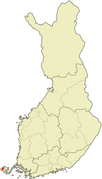
 Location of Hammarland in Finland |
||
| Location in Åland | ||
| Coordinates: 60°13′N 019°44′E / 60.217°N 19.733°ECoordinates: 60°13′N 019°44′E / 60.217°N 19.733°E | ||
| Country |
|
|
| Region | Åland | |
| Sub-region | Åland Countryside sub-region | |
| Government | ||
| • Municipal manager | Kurt Carlsson | |
| Area (2016-01-01) | ||
| • Total | 138.34 km2 (53.41 sq mi) | |
| • Land | 138.17 km2 (53.35 sq mi) | |
| • Water | 1,084.84 km2 (418.86 sq mi) | |
| Area rank | 285th largest in Finland | |
| Population (2016-03-31) | ||
| • Total | 1,521 | |
| • Rank | 285th largest in Finland | |
| • Density | 11.01/km2 (28.5/sq mi) | |
| Population by native language | ||
| • Swedish | 95.1% (official) | |
| • Finnish | 2.9% | |
| • Others | 1.9% | |
| Population by age | ||
| • 0 to 14 | 17.5% | |
| • 15 to 64 | 64.9% | |
| • 65 or older | 17.6% | |
| Time zone | EET (UTC+2) | |
| • Summer (DST) | EEST (UTC+3) | |
| Municipal tax rate | 16.5% | |
| Website | www.hammarland.ax | |
Hammarland is a municipality of Åland, an autonomous territory of Finland.
The municipality has a population of 1,521 (31 March 2016) and covers an area of 138.34 square kilometres (53.41 sq mi) of which 1,084.84 km2 (418.86 sq mi) is water. The population density is 11.01 inhabitants per square kilometre (28.5/sq mi).
The municipality is unilingually Swedish. 95% of its population has Swedish as their native language, making Hammarland one of the municipalities with the highest percentage of Swedish-speakers in Finland, and possibly in the world.
Märket, the westernmost point of Finland, is an exclave of Hammarland.
...
Wikipedia


