Märket

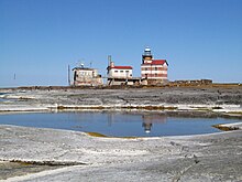
Märket Island with the unusual national border of 1985.
|
|
| Geography | |
|---|---|
| Location | Baltic Sea |
| Coordinates | 60°18′03″N 019°07′53″E / 60.30083°N 19.13139°ECoordinates: 60°18′03″N 019°07′53″E / 60.30083°N 19.13139°E |
| Area | 0.03 km2 (0.012 sq mi) |
| Length | 0.35 km (0.217 mi) |
| Width | 0.15 km (0.093 mi) |
| Administration | |
| Region | Åland Islands |
| Provinces | Uppland |
| Demographics | |
| Population | 0 |

Märket Lighthouse
|
|
|
Finland
|
|
| Location | Märket Islet, Baltic Sea |
|---|---|
| Coordinates | 60°18′04″N 19°07′53″E / 60.301008°N 19.131432°E |
| Year first constructed | 1885 |
| Automated | 1979 |
| Construction | stone and cast iron tower |
| Tower shape | cylindrical tower on an octagonal basement rising from a 2-story keeper’s house |
| Markings / pattern | white tower and lantern |
| Height | 14 metres (46 ft) |
| Focal height | 17 metres (56 ft) |
| Light source | solar and wind power |
| Characteristic | Fl W 5s. |
| Admiralty number | C4472 |
| NGA number | 16792 |
| ARLHS number | MAR-001 |
Märket ("The Mark", Swedish pronunciation: [ˈmærkə(t)]) is a small 3.3-hectare (8.2-acre) uninhabited skerry in the Baltic Sea between Sweden and Finland (in the area of the autonomous Åland Islands), which has been divided between two sovereignties since the Treaty of Fredrikshamn of 1809 defined the border between Sweden and the Russian Empire as going through the middle of the island. The westernmost land point of Finland is on Märket. The Finnish side of the island is part of the Municipality of Hammarland. The Swedish part of the island is itself divided by two counties of Sweden: Uppsala County (Östhammar Municipality) and (Norrtälje Municipality).
The 6-nautical-mile-wide (11 km; 6.9 mi) Understen–Märket Passage links the Bothnian Sea to the Baltic proper. The skerry is roughly 350 metres (1,150 ft) long by 150 metres (490 ft) wide, and its area is about 3.3 hectares (8.2 acres). It is the smallest sea island shared by two countries.
The name Märket ('the Mark') probably comes from its usefulness as a navigation mark before there were lighthouses. The route between Sweden and Åland has a passage of about 27 kilometres (15 NM) (17 mi) length over open sea. Before the lighthouse, the island and its shallows were dangerous navigational hazards, which seafarers tried to desperately avoid. In 1873, as many as 23 ships were grounded on the Swedish coast and its archipelago trying to avoid Märket, and eight of them were shipwrecked. Märket is detached from the main Åland archipelago, with the closest island more than 10 km away, and the closest harbor, Berghamn, 23 km away in Eckerö. There are small, barely surfacing rocks northwest of Märket, called Märketshällor ("stones of Märket"), which are too small to sustain vegetation.
...
Wikipedia

