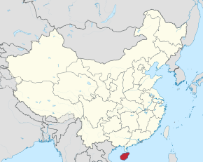
Hainan Province
|
Hainan Province 海南省 |
|
|---|---|
| Province | |
| Name transcription(s) | |
| • Chinese | 海南省 (Hǎinán Shěng) |
| • Abbreviation | simplified Chinese: 琼; traditional Chinese: 瓊 (pinyin: Qióng, POJ: khêng, Jyutping: king4) |
| • Hainanese | Hái-nâm-séng |
| • Yue Jyutping | Hoi2 Naam4 Saang2 |
 Map showing the location of Hainan Province |
|
| Coordinates: 19°12′N 109°42′E / 19.2°N 109.7°ECoordinates: 19°12′N 109°42′E / 19.2°N 109.7°E | |
| Named for |
hǎi – sea nán – south "South of the Sea [Qiongzhou Strait]" |
| Capital (and largest city) |
Haikou |
| Divisions | 4 prefectures, 20 counties, 218 townships |
| Government | |
| • Secretary | Liu Cigui |
| • Governor | Shen Xiaoming |
| Area | |
| • Total | 35,400 km2 (13,700 sq mi) |
| Area rank | 28th |
| Population (2015) | |
| • Total | 9,110,000 |
| • Rank | 28th |
| • Density | 260/km2 (670/sq mi) |
| • Density rank | 17th |
| Demographics | |
| • Ethnic composition |
Han – 82.6% Li – 15.84% Miao – 0.82% Zhuang – 0.67% |
| • Languages and dialects | Hainanese, Yue, Hlai |
| ISO 3166 code | CN-46 |
| GDP (2016) |
CNY 0.4 trillion USD 61 billion (28th) |
| • per capita |
CNY 44,405 USD 6,687 (18th) |
| HDI (2014) | 0.738 (high) (19th) |
| Website | www |
| Native name: 海南岛 | |
|---|---|
 |
|
| Geography | |
| Location | East Asia |
| Area | 33,210 km2 (12,820 sq mi) |
| Area rank | 42nd |
| Length | 156 km (96.9 mi) |
| Width | 170 km (106 mi) |
| Highest elevation | 1,840 m (6,040 ft) |
| Highest point | Wuzhi Mountain |
| Administration | |
|
People's Republic of China
|
|
| Province | Hainan |
| Largest settlement | Haikou (pop. 2,046,189) |
| Demographics | |
| Population | approx. 8,180,000 |
| Ethnic groups | Han, Li, Miao, Zhuang |
| Hainan | |||||||||||||||||||||

"Hainan" in Chinese characters
|
|||||||||||||||||||||
| Chinese | |||||||||||||||||||||
|---|---|---|---|---|---|---|---|---|---|---|---|---|---|---|---|---|---|---|---|---|---|
| Literal meaning | South of the Sea | ||||||||||||||||||||
|
|||||||||||||||||||||
| Transcriptions | |
|---|---|
| Standard Mandarin | |
| Hanyu Pinyin | |
| Wade–Giles | Hai3-nan2 |
| IPA | [xài.nǎn] |
| Yue: Cantonese | |
| Yale Romanization | Hói-nàahm |
| Jyutping | Hoi2-naam4 |
| Southern Min | |
| Hainanese Romanization | Hái-nâm |
| Hainan Island | |||||||

A 19th-century map of Hainan Island
|
|||||||
| Simplified Chinese | |||||||
|---|---|---|---|---|---|---|---|
| Literal meaning | Island South of the Sea | ||||||
|
|||||||
| Transcriptions | |
|---|---|
| Standard Mandarin | |
| Hanyu Pinyin | Hǎinán Dǎo |
| Former names | |||||||
| Zhuya | |||||||
|---|---|---|---|---|---|---|---|
| Chinese | |||||||
| Literal meaning | Pearl Cliffs | ||||||
|
|||||||
| Qiongya | |||||||
| Traditional Chinese | |||||||
| Simplified Chinese | |||||||
| Literal meaning | Jade Cliffs | ||||||
|
|||||||
| Qiongzhou | |||||||
| Traditional Chinese | |||||||
| Simplified Chinese | |||||||
| Literal meaning | Jade Prefecture | ||||||
|
|||||||
| Transcriptions | |
|---|---|
| Standard Mandarin | |
| Hanyu Pinyin | Zhūyá |
| Transcriptions | |
|---|---|
| Standard Mandarin | |
| Hanyu Pinyin | Qióngyá |
| Transcriptions | |
|---|---|
| Standard Mandarin | |
| Hanyu Pinyin | Qióngzhōu |
Hainan is the smallest and southernmost province of the People's Republic of China, consisting of various islands in the South China Sea. Hainan Island, separated from Guangdong's Leizhou Peninsula by the Qiongzhou Strait, is the largest island under PRC control (Taiwan, which is slightly larger, is also claimed but not controlled by the PRC) and makes up the majority of the province. The province has an area of 33,920 square kilometers (13,100 sq mi), with Hainan Island making up 32,900 square kilometers (12,700 sq mi) (97%) and the rest divided among two hundred islands scattered across three archipelagos. It was administered as part of Guangdong until 1988, when it became a separate province; around the same time, it was made the largest Special Economic Zone established by Deng Xiaoping as part of the Opening Up of China. There are a total of ten major cities and ten counties in Hainan Province. Haikou on the northern coast of Hainan Island is the capital while Sanya is a well-known tourist destination on the southern coast. The other major cities are Wenchang, Qionghai, Wanning, Wuzhishan, Dongfang, and Danzhou.
...
Wikipedia
