Grayson County, Texas
| Grayson County, Texas | ||
|---|---|---|

The Grayson County Courthouse in Sherman
|
||
|
||
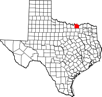
 Location in the U.S. state of Texas |
||
 Texas's location in the U.S. |
||
| Founded | 1846 | |
| Seat | Sherman | |
| Largest city | Sherman | |
| Area | ||
| • Total | 979 sq mi (2,536 km2) | |
| • Land | 933 sq mi (2,416 km2) | |
| • Water | 46 sq mi (119 km2), 4.7% | |
| Population | ||
| • (2010) | 120,877 | |
| • Density | 130/sq mi (50/km²) | |
| Congressional district | 4th | |
| Time zone | Central: UTC-6/-5 | |
| Website | www |
|
Grayson County is a county in the U.S. state of Texas. As of the 2010 census, its population was 120,877. The county seat is Sherman. The county was founded in 1846 and is named after Peter Wagener Grayson, an attorney general of the Republic of Texas.
Grayson County is included in the Sherman-Denison, TX Metropolitan Statistical Area, which is also included in the Dallas-Fort Worth-Arlington, TX Combined Statistical Area. It is also part of the Texoma region, with proximity to both Lake Texoma and the Red River.
The earliest known inhabitants of what is now Grayson County were Caddo amerindian groups, including Tonkawa, Ionis, and Kichai. These groups engaged in agriculture and traded with Spanish and French at trading posts along the Red River. This resulted in the establishment of trading posts at Preston Bend on the Red River, Warren, and Pilot Grove during 1836 and 1837.
After the establishment of Peters Colony in the early 1840s, settlement near the Red River became more rapid, and Grayson County was created from Fannin County by the Texas State Legislature on March 17, 1846. The county seat, Sherman, was also named by the Texas State Legislature.
In the 1850s, trading and marketing at Preston Bend became more important, as agriculture became more grew in the county. This was helped by Preston Road, the first trail in the state which went from Preston Bend to Austin, Texas. More growth occurred after the establishment of Sherman as station of the Butterfield Overland Mail route in 1856.
...
Wikipedia

