Texoma
| Texoma | |
|---|---|
| Region | |

Lake Texoma
|
|
 Map of Texoma Region |
|
| Country | |
| State |
|
| Largest city | Sherman |
| Area | |
| • Total | 14,961 km2 (5,776 sq mi) |
| • Land | 14,396 km2 (5,558 sq mi) |
| • Water | 565 km2 (218 sq mi) 3.8% |
| Population (2010) | |
| • Total | 319,455 |
| • Density | 21/km2 (55/sq mi) |
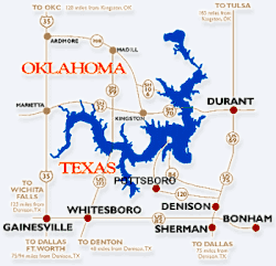
The coinage Texoma, a portmanteau of Texas and Oklahoma, is used to describe the area on either side of the border between these two states along the Red River valley, in particular the area around Lake Texoma. The surrounding area is alternatively referred to as Texomaland. The main area of the Texoma region is the area and surrounding cities near Lake Texoma which includes eight counties, a metropolitan area and three micropolitan areas. The Sherman–Denison Metropolitan as well as the Ardmore, Durant, and Gainesville micropolitan areas are the most populous areas of this region, although the area around Bonham is also very populated. Most of the region is also, a part of the Dallas–Fort Worth Combined Statistical Area.
Like many regional names, businesses use the term Texoma in their name to describe their intended service area.
A portion of the Texoma area south of Lake Texoma has been designated an American Viticultural Area, the Texoma AVA. The Texas part of Texoma is served by the Texoma Council of Governments.
The Wichita Falls–Lawton area as well as the Paris–Hugo area are also referred to as "Texoma" or "Texomaland" due to their proximity to the Red River and the Texas/Oklahoma border.
...
Wikipedia
