Fannin County, Texas
| Fannin County, Texas | |
|---|---|

Fannin County Courthouse in Bonham
|
|
 Location in the U.S. state of Texas |
|
 Texas's location in the U.S. |
|
| Founded | 1838 |
| Named for | James Fannin |
| Seat | Bonham |
| Largest city | Bonham |
| Area | |
| • Total | 899 sq mi (2,328 km2) |
| • Land | 891 sq mi (2,308 km2) |
| • Water | 8.0 sq mi (21 km2), 0.9% |
| Population | |
| • (2010) | 33,915 |
| • Density | 38/sq mi (15/km²) |
| Congressional district | 4th |
| Time zone | Central: UTC-6/-5 |
| Website | www |
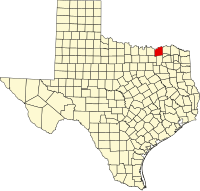
Fannin County is a county in the U.S. state of Texas. As of the 2010 census, its population was 33,915. The county seat is Bonham. The county was named for James Fannin, who commanded the group of Texans killed in the Goliad Massacre during the Texas Revolution. {James Bonham (the county seat's namesake) sought Fannin's assistance for the Battle of the Alamo (Fannin, however, was unable to provide assistance).}
The county was created in 1837 and organized the next year.
Fannin County is a part of the Texoma region.
According to the U.S. Census Bureau, the county has a total area of 899 square miles (2,330 km2), of which 891 square miles (2,310 km2) is land and 8.0 square miles (21 km2) (0.9%) is water. It is drained by Bois D'Arc Creek and Sulphur River.
As of the census of 2000, there were 31,242 people, 11,105 households, and 7,984 families residing in the county. The population density was 35 people per square mile (14/km²). There were 12,887 housing units at an average density of 14 per square mile (6/km²). The racial makeup of the county was 86.56% White, 7.96% Black or African American, 0.92% Native American, 0.26% Asian, 0.03% Pacific Islander, 2.78% from other races, and 1.49% from two or more races. 5.61% of the population were Hispanic or Latino of any race. As of 2015 the largest self-reported ancestry groups were 48.50% English, 16.10% Welsh, 11.00% German and 7.25% Irish.
...
Wikipedia
