Glan-Münchweiler
| Glan-Münchweiler | ||
|---|---|---|
|
||
| Coordinates: 49°28′17″N 7°26′46″E / 49.47139°N 7.44611°ECoordinates: 49°28′17″N 7°26′46″E / 49.47139°N 7.44611°E | ||
| Country | Germany | |
| State | Rhineland-Palatinate | |
| District | Kusel | |
| Municipal assoc. | Oberes Glantal | |
| Government | ||
| • Mayor | Fred Müller (CDU) | |
| Area | ||
| • Total | 5.99 km2 (2.31 sq mi) | |
| Elevation | 222 m (728 ft) | |
| Population (2015-12-31) | ||
| • Total | 1,224 | |
| • Density | 200/km2 (530/sq mi) | |
| Time zone | CET/CEST (UTC+1/+2) | |
| Postal codes | 66907 | |
| Dialling codes | 06383 | |
| Vehicle registration | KUS | |
| Website | www.vg-glm.de | |
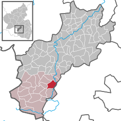
Glan-Münchweiler is an Ortsgemeinde – a municipality belonging to a Verbandsgemeinde, a kind of collective municipality – in the Kusel district in Rhineland-Palatinate, Germany. It belongs to the Verbandsgemeinde of Oberes Glantal.
The municipality lies in a hollow in the Glan valley in the uplands in the Western Palatinate, with peaks such as the Galgenberg, the Klopfberg, the Eckertsberg and the Wingertsberg. On the Glan’s right bank, at the foot of the Hochwald (“High Forest”) lies the outlying centre of Bettenhausen. The bottom of the dale has an elevation of 215 m above sea level. The highest elevation within municipal limits lies in the Eichenwald (“Oak Forest”) at 388 m above sea level. Glan-Münchweiler lies roughly 8 km southeast of Kusel and 25 km west of Kaiserslautern. The municipal area measures 464 ha, of which 112 ha is wooded.
Glan-Münchweiler borders in the north on the municipality of Rehweiler, in the east on the municipality of Niedermohr, in the south on the municipality of Nanzdietschweiler, in the southwest on the municipality of Börsborn, in the west on the municipality of Henschtal and in the northwest on the municipality of Quirnbach.
Glan-Münchweiler’s Ortsteile are Glan-Münchweiler (main centre) and Bettenhausen.
On the terrace that juts out from the western slope into the Glan valley, monks from the Hornbach Monastery established an estate in the 8th century for clearing and farming the surrounding countryside. The village core that arose here with its estate and church was fortified on the downstream side in 1344, as witnessed by “civic building”. After the Thirty Years' War, Glan-Münchweiler’s built-up area spread westwards towards what is today Marktstraße (“Market Street”). Ringstraße and Hauptstraße (“Main Street”) soon formed a residential quadrangle through which ran only one street from the village core, Kirchstraße (“Church Street”). With the opening of the building zone in the cadastral area known as “Teich” (“Pond”), the built-up area began to spread northwards in 1953 towards the slopes of the Fronberg and Galgenberg, stopping only at the ridge in many places. With the graveyard’s expansion in 1970, even Friedhofstraße (“Graveyard Street”) and the area below were opened up. The Autobahn, also finished in 1970, touches Glan-Münchweiler just at the southwest, tightly hemming the village’s development in. Only the sporting ground with its two football pitches and athletic complex could be laid out to the highway’s west. The supply road built for the Autobahn’s construction was developed after the Second World War and is now called Embachstraße. The forester’s house built in 1914 on the road leading out of Glan-Münchweiler towards Quirnbach served after the war as a kindergarten owned by the Catholic Church, although it is now under private ownership. At the turn of the millennium, Glan-Münchweiler had 27 streets and 358 houses.
...
Wikipedia


