Rehweiler
| Rehweiler | ||
|---|---|---|
|
||
| Coordinates: 49°29′7.82″N 7°26′29.94″E / 49.4855056°N 7.4416500°ECoordinates: 49°29′7.82″N 7°26′29.94″E / 49.4855056°N 7.4416500°E | ||
| Country | Germany | |
| State | Rhineland-Palatinate | |
| District | Kusel | |
| Municipal assoc. | Oberes Glantal | |
| Government | ||
| • Mayor | Thomas A. Herbach | |
| Area | ||
| • Total | 6.74 km2 (2.60 sq mi) | |
| Elevation | 220 m (720 ft) | |
| Population (2015-12-31) | ||
| • Total | 452 | |
| • Density | 67/km2 (170/sq mi) | |
| Time zone | CET/CEST (UTC+1/+2) | |
| Postal codes | 66907 | |
| Dialling codes | 06383 | |
| Vehicle registration | KUS | |
| Website | www.rehweiler.de | |
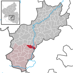
Rehweiler is an Ortsgemeinde – a municipality belonging to a Verbandsgemeinde, a kind of collective municipality – in the Kusel district in Rhineland-Palatinate, Germany. It belongs to the Verbandsgemeinde of Oberes Glantal.
The municipality lies in the Western Palatinate at a broadening of the Glan valley near the mouths of two brooks that empty into the Glan, the Rödelbach from the left and the Dorfbach from the right, roughly 210 m above sea level, while the settled parts of the flanking slopes reach some 300 m above sea level. The municipality’s highest point, in the municipal area’s far west, is 357 m above sea level. Near this peak runs the Autobahn A 62 (Kaiserslautern–Trier) for about one kilometre through the municipal area. Two continuous woodlands lie to the village’s east (Bannbusch) and west (Brandenbusch). The municipal area measures 673 ha, of which 167 ha is wooded.
Rehweiler borders in the north on the municipality of Theisbergstegen, in the northeast on the municipality of Matzenbach, in the east on the municipality of Niedermohr, in the south on the municipality of Glan-Münchweiler, in the southwest on the municipality of Quirnbach, in the west on the municipality of Hüffler and in the northwest on the municipality of Etschberg.
...
Wikipedia


