Geography of Victoria
 |
|
| Continent | Australia |
|---|---|
| Region | Southeast Australia |
| Coordinates |
37°31′S 149°58′E / 37.51°S 149.97°E — 33°58′S 140°58′E / 33.97°S 140.96°E |
| Area | Ranked 3rd among states and territories |
| • Total | 227,594 km2 (87,875 sq mi) |
| Borders | Land borders: New South Wales, South Australia. Maritime Borders: Tasmania |
| Highest point |
Mount Bogong 1,986 m (6,516 ft) |
| Lowest point |
Bass Strait sea level |
| Longest river |
Goulburn River 654 km (406 mi) |
| Largest lake |
Gippsland Lakes 600 km² (373 sq mi) |
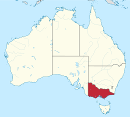
Victoria is the southernmost mainland state of Australia. With an area of 227,594 km² (87,874.5 sq mi), it is Australia's sixth largest state or territory. The State is comparable in size to the US state of Utah or the island of Great Britain. It is bound to the northwest by South Australia, directly north by New South Wales, and also shares a maritime border with Tasmania to the south, across the Bass Strait. Most of Victoria's northern border lies along the Murray River. The eastern half of the state is dominated by the Great Dividing Range and the surrounding uplands, which also to a lesser extent extend far into the west of the state and ease off after The Grampians. By comparison the north and northwest of the state is extremely flat with little prominence. Approximately three quarters of Victoria's population lives on and around the coast of the Port Phillip and Western Port bays, chiefly in Melbourne, in Victoria's South Central region.
The geography of Victoria has several different divisions depending on the aspect of the geography in question. Geomorphological divisions are listed in the following sections. From a human geographical perspective, the state is divided up into the following regions:
Centred on the main divide in eastern Victoria, the Eastern Uplands separate the streams and rivers draining north to the Murray-Darling Basin from those flowing southwards directly to the sea. It is the largest and most diverse geomorphic region in the State.
The main streams draining northwards are the Goulburn, Campaspe, Mitta Mitta, Kiewa, Loddon, Avoca, Wimmera, Ovens and King Rivers. The most important streams flowing southwards to the sea are the Latrobe, Thomson, Macalister, Mitchell, Tambo, Nicholson and Snowy Rivers and their tributaries. All these rivers, with the exception of the Snowy River, reach the sea through the Gippsland Lakes of south-eastern Victoria. Further east, the Bemm, Cann and Genoa Rivers flow directly into Bass Strait to drain the eastern division of the Eastern Uplands. The Yarra River, flowing into Port Phillip Bay, drains the southwest area of the Uplands. The south-west of the state is dominated by the Hopkins and Glenelg rivers. The longest river in Victoria is the Goulburn, which rises below the peak of Corn Hill (1,331 m) and flows into the Murray river near Echuca. It is over 650 kilometers long.
...
Wikipedia
