*** Welcome to piglix ***

Latrobe River

Latrobe(Durt'yowan, Tanjil)
La Trobe, LaTrobe
River
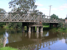
20100426 SaleSwingBridge.jpg
The Sale Swing Bridge over the Latrobe River.
Name origin: In honour of Charles La Trobe, Lieutenant Governor of the Port Phillip District.
Country Australia
State Victoria
Regions South East Coastal Plain (IBRA), West Gippsland
Local government areas Baw Baw, Wellington, East Gippsland
Part of West Gippsland catchment
Tributaries
 - left Pioneer Creek, Ada River, Toorongo River, Loch River, Hawthorn Creek, Tanjil River, Anderson Creek, Tyers River, Rintoul Creek, Eaglehawk Creek, Thomson River, Avon River
 - right Bennie Creek, Morwell River, Wade Creek, Traralgon Creek, Flynns Creek
Landmarks Latrobe Valley, Gippsland Lakes
Source Baw Baw plateau, Great Dividing Range
 - location below Dick Hill, near Noojee
 - elevation 764 m (2,507 ft)
 - coordinates 37°49′33″S 145°47′39″E / 37.82583°S 145.79417°E / -37.82583; 145.79417
Mouth Lake Wellington
 - location east of Sale
 - elevation 1 m (3 ft)
 - coordinates 37°54′11″S 147°37′20″E / 37.90306°S 147.62222°E / -37.90306; 147.62222Coordinates: 37°54′11″S 147°37′20″E / 37.90306°S 147.62222°E / -37.90306; 147.62222
Length 270 km (168 mi)
National parks The Lakes NP,
Gippsland Lakes CP
Reservoir and lakes Lake Narracan, Lake Victoria, Lake Wellington
Nature reserves Noojee Streamside Reserve, Tyers Streamside Reserve
Latrobe River is located in Victoria
Latrobe River
Location of the Latrobe River mouth in Victoria

The Latrobe River (or sometimes La Trobe or LaTrobe) is a perennial river of the West Gippsland catchment, located in the West Gippsland region of the Australian state of Victoria. The Latrobe River and its associated sub-catchment is an important source for the Gippsland Lakes, draining the south eastern slopes of the Great Dividing Range.

The Latrobe River rises below Dick Hill, from the southern slopes of the Baw Baw plateau, part of the Great Dividing Range, between Powelltown and Noojee where it shares a watershed with the Little Yarra River, in a state forestry area. The river flows generally in an easterly direction, then south, and then east again through the Latrobe Valley, joined by seventeen tributaries including the Ada, Toorongo, Loch, Tanjil, Morwell, Tyers, and Thomson rivers, before reaching its mouth in Lake Wellington east of Sale where it forms it's confluence with the Avon. It then goes to flow out of Lake Wellington and into Lake Victoria, Within Lake Victoria, south of Bairnsdale, the river forms its confluence with the Forge Creek and Mitchell River and empties into Bass Strait southwest of Lakes Entrance in the Shire of East Gippsland. The river descends 764 metres (2,507 ft) over its 270-kilometre (170 mi) course.


...
Wikipedia

...