Echuca
|
Echuca Victoria |
|||||||
|---|---|---|---|---|---|---|---|

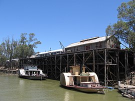
Echuca's main landmark,
its historic wharf on the Murray River |
|||||||
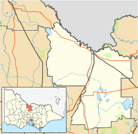
| Coordinates | 36°08′0″S 144°45′0″E / 36.13333°S 144.75000°ECoordinates: 36°08′0″S 144°45′0″E / 36.13333°S 144.75000°E | ||||||
| Population | 12,983 (2011 census) | ||||||
| Postcode(s) | 3564 | ||||||
| Elevation | 96 m (315 ft) | ||||||
| Location |
|
||||||
| LGA(s) | Shire of Campaspe | ||||||
| State electorate(s) | Murray Plains | ||||||
| Federal Division(s) | Murray | ||||||
|
|||||||
Echuca (/əˈtʃuːkə/ ə-CHOO-kə) Echuca is a town located on the banks of the Murray River and Campaspe River in Victoria, Australia. The border town of Moama is adjacent on the northern side of the Murray River in New South Wales. Echuca is the administrative centre and largest settlement in the Shire of Campaspe. As of the 2011 census, Echuca had a population of 13,708. The population of the combined Echuca and Moama townships was estimated be 20,365 at June 2015.
Echuca, an Aboriginal name meaning "Meeting of the Waters", is indicative of the role rivers have played in the town's existence. Echuca is situated close to the junction of the Goulburn, Campaspe, and Murray Rivers. Its position at the closest point of the Murray to Melbourne contributed to its development as a thriving river port city during the 19th century.
Echuca was founded by one of the most enterprising characters of the early colonial days, an ex-convict named Henry Hopwood. In 1850 he bought a small punt which operated across the Murray River near the Campaspe junction. The relatively small settlement known as "Hopwood's Ferry" became Echuca as the town grew. The Post Office known as Hopwoods Punt opened around 1854 and was renamed Echuca on 1 January 1855.
...
Wikipedia

