Gavdos
|
Gavdos Γαύδος |
|
|---|---|

Gavdos island satellite image.
|
|
| Coordinates: 34°50′N 24°05′E / 34.833°N 24.083°ECoordinates: 34°50′N 24°05′E / 34.833°N 24.083°E | |
| Country | Greece |
| Administrative region | Crete |
| Regional unit | Chania |
| Area | |
| • Municipality | 32.4 km2 (12.5 sq mi) |
| Highest elevation | 345 m (1,132 ft) |
| Lowest elevation | 0 m (0 ft) |
| Population (2011) | |
| • Municipality | 152 |
| • Municipality density | 4.7/km2 (12/sq mi) |
| Time zone | EET (UTC+2) |
| • Summer (DST) | EEST (UTC+3) |
| Postal code | 730 01 |
| Area code(s) | 28230 |
| Vehicle registration | ΧΝ |
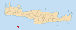
Gavdos (Greek: Γαύδος, [ˈɣavðos]) is the southernmost Greek island, located to the south of its much larger neighbour, Crete, of which it is administratively a part, in the regional unit of Chania. It forms a community with surrounding islets and was part of the former Selino Province. The island is situated at the southern tip of Greece, thus making it the southernmost point of the entire European continent.
Gavdos has been known by a wide variety of names. For example, it appears in the biblical account of Paul's journey to Rome in Acts 27 as "Clauda" (Κλαῦδα) or "Cauda" (Καῦδα). The island was also referred to as "Cauda" by Roman geographer Pomponius Mela, and as "Gaudos" by Pliny. Ptolemy called Gavdos "Claudos" (Κλαῦδος). The Venetians called it "Gotzo", perhaps in imitation of the Maltese island "Gozo". From the 17th to the 19th centuries, the island was known as "Gondzo". A Turkish name of Godzo was "Bougadoz".
The island is 26 nautical miles (48 km) south of Chora Sfakion. The area of the municipality, which includes the small island Gavdopoula, is 32.424 square kilometres (12.5 sq mi). The island is roughly triangular in shape. Its highest point is Mount Vardia, 345 metres (1,132 feet). The southeastern corner is a rocky peninsula with a natural arch carved by the elements, called Trypiti. A sculpture of an oversized chair sits on top of Trypiti.
...
Wikipedia


