Fort Benton, Montana
| Fort Benton, Montana | |
|---|---|
| City | |

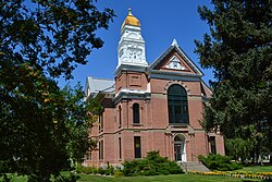
Chouteau County Courthouse
|
|
| Nickname(s): "The Birth Place Of Montana" | |
 Location of Fort Benton, Montana |
|
| Coordinates: 47°49′10″N 110°40′11″W / 47.81944°N 110.66972°WCoordinates: 47°49′10″N 110°40′11″W / 47.81944°N 110.66972°W | |
| Country | United States |
| State | Montana |
| County | Chouteau |
| Area | |
| • Total | 2.07 sq mi (5.36 km2) |
| • Land | 2.07 sq mi (5.36 km2) |
| • Water | 0 sq mi (0 km2) |
| Elevation | 2,621 ft (799 m) |
| Population (2010) | |
| • Total | 1,464 |
| • Estimate (2015) | 1,460 |
| • Density | 707.2/sq mi (273.1/km2) |
| Time zone | Mountain (MST) (UTC-7) |
| • Summer (DST) | MDT (UTC-6) |
| ZIP code | 59442 |
| Area code(s) | 406 |
| FIPS code | 30-28000 |
| GNIS feature ID | 1750122 |
| Website | www.fortbenton.com |
|
Fort Benton
|
|
 |
|
| Location | Fort Benton, Montana |
|---|---|
| Built | 1846 |
| NRHP Reference # | 66000431 |
| Significant dates | |
| Added to NRHP | October 15, 1966 |
| Designated NHLD | November 15, 1961 |
Fort Benton is a city in and the county seat of Chouteau County, Montana, United States. A portion of the city was designated as a National Historic Landmark District in 1961. Established in 1846, a full generation before the U.S. Civil War, Fort Benton is one of the oldest settlements in the American West; in contrast, many other places—including large cities today—were settled in the late 1860s, 1870s, or 1880s.
The population was 1,464 at the 2010 census.
Established by European-Americans Auguste Chouteau and Pierre Chouteau, Jr. of St. Louis in 1847 as the last fur trading post on the Upper Missouri River, the fort became an important economic center. For 30 years, the port attracted steamboats carrying goods, merchants, gold miners and settlers, coming from New Orleans, Memphis, St. Louis, Hannibal, Bismarck, Kansas City, etc. As the terminus for the 642-mile-long Mullan Road, completed by the US Army in 1860, Fort Benton was part of the overland link between trade on the Missouri River and the Columbia River, at Fort Walla Walla, Washington. Twenty thousand migrants used the road in the first year to travel to the Northwest. It became an important route for miners from both directions going into the interior of Idaho, and north to Canada. Riverboat travel to Fort Benton further provided an important route for miners to the newly discovered gold fields of southern Montana at what became Bannack and Virginia City beginning in 1862, and Helena, beginning in 1865.
...
Wikipedia


