Flint River (Michigan)
| Flint River | |
|---|---|

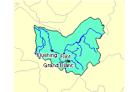
The Flint River Watershed
|
|
| Country | United States |
| Basin features | |
| Main source | Lapeer County, Michigan |
| River mouth | Saginaw River |
| Basin size | Saginaw River watershed |
| Physical characteristics | |
| Length | 78 miles (126 km) |
The Flint River is a 78.3-mile-long (126.0 km) river in the Flint/Tri-Cities region of Michigan in the United States. The river's headwaters are in Columbiaville in Lapeer County and flows through the counties of Lapeer, Genesee, and Saginaw. The cities of Lapeer, Flint, Flushing, and Montrose are along its course.
The river's name is a translation from the Ojibwe language Biiwaanagoonh-ziibi (Flinty River). For a time, an Indian Reservation named Pewonigowink (Biiwaanagoonying: By the Flinty [River]) existed near Genesee, Michigan.
The Flint River drains 1,332 square miles (3,450 km2) of Michigan, in Lapeer, Genesee, Shiawassee, Saginaw, Oakland, Tuscola, and Sanilac counties.
The river forms in Lapeer County near Columbiaville where the river's South Branch and North Branch come together. Its volume is supplemented by numerous creeks, including: Kearsley Creek, Thread Creek and Swartz Creek in Genesee County, and Misteguay Creek in Saginaw County. The river flows in a southwesterly direction past Flint before turning northward near Flushing. It empties into the Shiawassee River in the Shiawassee National Wildlife Refuge near the city of Saginaw, as do the Bad River and Cass River. The Shiawassee then converges with the Tittabawassee River to form the Saginaw River. The Saginaw empties into the Saginaw Bay of Lake Huron.
...
Wikipedia
