Saginaw River
| Saginaw River | |
|---|---|

Saginaw River watershed
|
|
| Basin features | |
| Main source |
Saginaw, Michigan 43°23′14″N 83°57′58″W / 43.38724°N 83.96608°W |
| River mouth |
Saginaw Bay, Michigan 43°38′49″N 83°51′02″W / 43.64696°N 83.85053°WCoordinates: 43°38′49″N 83°51′02″W / 43.64696°N 83.85053°W |
| Basin size | 8,595 sq mi (22,260 km2) |
| Physical characteristics | |
| Length | 22 mi (35 km) |
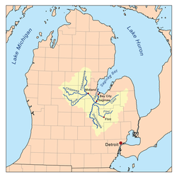
The Saginaw River is a 22.4-mile-long (36.0 km)river in the U.S. state of Michigan. It is formed by the confluence of the Tittabawassee and Shiawassee rivers southwest of Saginaw. It flows northward into the Saginaw Bay of Lake Huron, passing through Bay City, which developed around it in the 19th century. The watershed area is 8,595 square miles (22,260 km2).
The river is an important shipping route for Mid-Michigan, passing through the cities of Saginaw and Bay City. It is one of Michigan's few inland navigable rivers. The Saginaw River Rear Range Light, one of a pair of lighthouses built in 1876 to improve navigation, was listed on the National Register of Historic Places in 1984. Since the turn of the 21st century, it is being renovated.
The Saginaw River was used for fishing and as a transportation route by canoe by indigenous peoples for thousands of years prior to European colonization. From the 18th century, fur traders and trappers rendezvoused at a post at the mouth or traveled along the river and its tributaries to trade with the Ojibwe tribes of the region for European and American manufactured goods.
As towns developed along the river, it supported additional travel inland, as well as powering the operation of sawmills and later factories. The first lighthouse was completed in 1841, and a pair of lighthouses were built in range configuration in 1876. They were converted to electricity in 1915. The Saginaw River Rear Range Light was listed on the National Register of Historic Places in 1984. Since the turn of the 21st century, it is being renovated.
...
Wikipedia
