Flathead River
| Flathead River | |
|
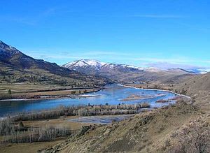
The river near Perma, Montana
|
|
| Countries | United States, Canada |
|---|---|
| State | Montana |
| Province | British Columbia |
| Tributaries | |
| - left | Middle Fork Flathead River, South Fork Flathead River, Swan River (Montana) |
| - right | North Fork Flathead River |
| Source | Confluence of North Fork and Middle Fork Flathead River |
| - location | Rocky Mountains |
| - elevation | 3,120 ft (951 m) |
| - coordinates | 48°28′2″N 114°4′10″W / 48.46722°N 114.06944°W |
| Mouth | Clark Fork |
| - elevation | 2,484 ft (757 m) |
| - coordinates | 47°21′56″N 114°46′34″W / 47.36556°N 114.77611°WCoordinates: 47°21′56″N 114°46′34″W / 47.36556°N 114.77611°W |
| Length | 158 mi (254 km) |
| Basin | 8,795 sq mi (22,779 km2) |
| Discharge | for near mouth, at Perma, MT; max at Polson, MT |
| - average | 11,380 cu ft/s (322 m3/s) |
| - max | 110,000 cu ft/s (3,115 m3/s) |
| - min | 2,670 cu ft/s (76 m3/s) |
|
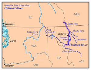
Map of the Flathead River, its tributary forks and downriver connection to the Columbia River via Clark Fork and the Pend Oreille River
|
|
The Flathead River (Salish: ntx̣ʷetkʷ, ntx̣ʷe ), in the northwestern part of the U.S. state of Montana, originates in the Canadian Rockies to the north of Glacier National Park and flows southwest into Flathead Lake, then after a journey of 158 miles (254 km), empties into the Clark Fork. The river is part of the Columbia River drainage basin, as the Clark Fork is a tributary of the Pend Oreille River, a Columbia River tributary. With a drainage basin extending over 8,795 square miles (22,780 km2) and an average discharge of 11,380 cubic feet per second (322 m3/s), the Flathead is the largest tributary of the Clark Fork and constitutes over half of its flow.
The Flathead River rises in forks in the Rocky Mountains of northwestern Montana. The largest tributary is the North southwards. The North Fork is sometimes considered the main stem of the Flathead River. Near West Glacier the North Fork combines with the Middle Fork to form the main Flathead River. The river then flows westwards to join the South Fork and cuts between the Whitefish Range and Swan Range via Bad Rock Canyon. All of the headwaters forks are entirely or in part designated National Wild and Scenic Rivers. After the river leaves the canyon it flows into the broad Flathead Valley and arcs southwest, passing Columbia Falls and Kalispell, before joining the Whitefish River and emptying into Flathead Lake, where the Swan River joins.
...
Wikipedia


