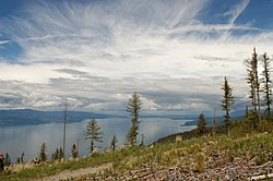
Flathead Lake
| Flathead Lake | |
|---|---|
 |
|
| Location | Lake / Flathead counties, Montana, US |
| Coordinates | 47°54′6″N 114°6′15″W / 47.90167°N 114.10417°WCoordinates: 47°54′6″N 114°6′15″W / 47.90167°N 114.10417°W |
| Type | Moraine-dammed lake |
| Primary inflows |
Flathead River Swan River |
| Primary outflows | Flathead River |
| Catchment area | 8,587 sq mi (22,240 km2) |
| Basin countries | United States |
| Max. length | 27.3 mi (43.9 km) |
| Max. width | 15.5 mi (24.9 km) |
| Surface area | 197 sq mi (510 km2) |
| Average depth | 164.7 ft (50.2 m) |
| Max. depth | 370.7 ft (113.0 m) |
| Water volume | 5.56 cu mi (23.2 km3) |
| Residence time | 3.4 years |
| Shore length1 | 161.4 mi (259.7 km) |
| Surface elevation | 2,894 ft (882 m) |
| Islands | Wild Horse Island; Cromwell, Bird, Bull, Little Bull, Melita, Shelter, Cedar, Mother-in-Law, Dream, Goose, Mary B, Rock Island; Douglas Islands |
| Settlements | 7 miles (11 km) south of Kalispell, Montana |
| 1 Shore length is not a well-defined measure. | |
Flathead Lake (Salish: člq̓etkʷ ) is the largest natural freshwater lake by surface area that is west of the Mississippi River in the contiguous United States, if one takes Red Lake and Lake of the Woods to be north of the Mississippi River, rather than west of the river.
With a surface area of between 191.5 sq mi (496 km2) and 197 sq mi (510 km2), Flathead Lake is slightly larger in surface area than Lake Tahoe, but it is much smaller in volume.
The lake is a remnant of the ancient, massive glacial dammed lake, Lake Missoula of the era of the last interglacial. Flathead Lake is 27.3 mi (43.9 km) long and up to 15.5 mi (24.9 km) wide. Flathead Lake has a maximum depth of 370.7 ft (113.0 m), and an average of 164.7 ft (50.2 m). This makes Flathead Lake deeper than the average depths of the Yellow Sea or the Persian Gulf. Polson Bay, at the lake's outlet, was raised 10 ft (3.0 m) by Kerr Dam. It is one of the cleanest lakes in the populated world for its size and type.
Located in the northwest corner of the state of Montana, 7 miles (11 km) south of Kalispell, it is approximately 30 miles (50 km) long and 16 miles (25 km) wide, covering 191.5 square miles (495.9 km²), making it approximate in size to Minnesota's Mille Lacs Lake and half the area of San Francisco Bay (main bay). Flathead Lake is 30 miles (48 km) southwest of Glacier National Park and is flanked by two scenic highways, which wind along its curving shoreline. On the west side is U.S. Route 93, and on the east, is Route 35.
...
Wikipedia
