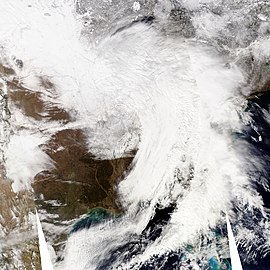
February 9–10, 2010 North American blizzard
| Category 2 "Significant" (RSI: 3.12) | |

Weather conditions on February 9, 2010 (day 2).
|
|
| Type |
Extratropical cyclone Winter storm Blizzard |
|---|---|
| Formed | February 7, 2010 |
| Dissipated | February 11, 2010 |
| Lowest pressure | 969 millibars (28.6 inHg) |
| Maximum snowfall or ice accretion | Laurel Hill, Maryland: 61.2 inches |
| Casualties | 3 fatalities |
| Areas affected |
Midwestern United States, Mid-Atlantic region, and New England (from Illinois to Virginia to Vermont) Eastern Canada |
| Part of the 2009–10 North American winter storms | |
The February 9–10, 2010 North American blizzard was a winter and severe weather event that afflicted the Midwest, Mid-Atlantic and New England regions of the United States between February 9–11, 2010, affecting some of the same regions that had experienced a historic Nor'easter three days prior. The storm brought 10 to 20 inches (25 to 51 cm) of snow across a wide swath from Washington, DC to New York City, with parts of the Baltimore metro area receiving more than 20 inches (51 cm). This storm began as a classic "Alberta clipper", starting out in Canada and then moving southeast, and finally curving northeast while rapidly intensifying off the New Jersey coast, forming an eye. The National Weather Service, in an interview with The Baltimore Sun's weather reporter Frank Roylance, likened this storm to a Category 1 hurricane. Forecasters told Roylance that "Winds topped 58 mph over part of the Chesapeake Bay, and 40 mph gusts were common across the region as the storm's center deepened and drifted slowly along the mid-Atlantic coast". This storm system, in conjunction with the first storm 3 days prior, has been nicknamed Snoverkill.
This storm appeared similar to the North American Blizzard of 2005 because it redeveloped off the Atlantic coast and intensified into a powerful nor'easter. This storm began around Big Bend of Texas on the morning of the 8th. It moved northeast and reached the Tennessee Valley on the morning of the 9th. At 7 p.m. EST on the 9th, it was located near Charleston, South Carolina. It then moved north-northeast, near Norfolk, Virginia at 1 a.m. EST on the 10th, Georgetown, Delaware at 7 a.m. EST, Atlantic City, New Jersey at 10 a.m. EST, and just east of Seaside Heights, New Jersey at 4 p.m. EST. The low pressure system then drifted slowly east the rest of the afternoon into the overnight of the 10th.
Because this storm affected some of the same areas that already received historic snow totals from the February 5–6, 2010 North American blizzard, it only exacerbated the cleanup process, with cities still being paralyzed from the last storm. Numerous cities shattered their seasonal snowfall records as of February 11, including the following (more snow fell at each of these locations later that month):
...
Wikipedia
