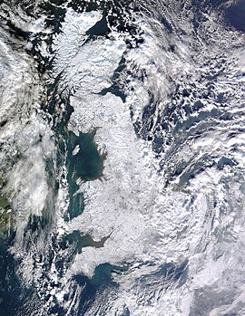
Global storm activity of 2010

A satellite photo showing most of the UK. It shows the extent of snow cover across the entire island. From Plymouth in the south to Aberdeen in the north, the UK was hit with the heaviest snowfall in 32 years.
|
|
| Formed | August 21, 2009 |
|---|---|
| Dissipated | August 31, 2010 |
| Lowest pressure | 945 millibars (27.9 inHg) over the North Atlantic |
| Lowest temperature | −45.6 °C (−50.1 °F) (Folldal, Norway) |
| Maximum snowfall or ice accretion | 53.0 in (135 cm) (The town of Potter Hollow, New York) |
| Damage | Unknown |
| Areas affected | Northern Hemisphere |
The global storm activity of 2010 includes major meteorological events in the Earth's atmosphere during the year, including winter storms (blizzards, ice storms, European windstorms), hailstorms, out of season monsoon rain storms, extratropical cyclones, gales, microbursts, flooding, rainstorms, tropical cyclones, and other severe weather events.
The thunderstorm season for the Northern Hemisphere began this time of year, beginning on March 1, and ending on August 31.
Fresh overnight snowfall on New Year's Eve and New Year's Day caused disruption in north east England, with roads across Northumberland, Tyne and Wear, County Durham and Teesside affected. Snow also fell in parts of East Cumbria. In places it was as deep as 10 centimetres (3.9 in) and motorists were warned not to travel unless their journey was absolutely necessary.
A major snow-related weather warning was put out in Alaska on December 30. The expected snowstorm was probably part of the same weather system that hit the Russian Far East from December 30 to January 5.
Between January 1 and 2, 2010, 50- and 70-year record low temperatures and snowfall hit northern China and Korea starting January 1. Blizzards also hit Mongolia's Dundgobi province.
...
Wikipedia
