El Paso, TX
| El Paso, Texas | |||
|---|---|---|---|
| City | |||
| City of El Paso | |||

From upper left: downtown El Paso skyline, star on the Franklin Mountains, The Cathedral of Saint Patrick, Wyler Aerial Tramway, North Franklin Peak, downtown El Paso at night
|
|||
|
|||
| Nickname(s): The Sun City, El Chuco | |||
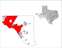
 Location in El Paso County and the state of Texas |
|||
| Location in the United States of America | |||
| Coordinates: 31°47′25″N 106°25′24″W / 31.79028°N 106.42333°WCoordinates: 31°47′25″N 106°25′24″W / 31.79028°N 106.42333°W | |||
| Country | |||
| State |
|
||
| County | El Paso | ||
| Metropolitan Area | El Paso | ||
| Founded | 1680 | ||
| Incorporated | 1873 | ||
| Government | |||
| • Type | Council–manager | ||
| • City Council |
Mayor Oscar Leeser (D) Peter Svarzbein Jim Tolbert Emma Acosta Carl L. Robinson Dr. Michiel Noe Claudia Ordaz Lily Limon Cortney Niland |
||
| • City manager | Tommy Gonzalez | ||
| Area | |||
| • City | 256.3 sq mi (663.7 km2) | ||
| • Land | 255.3 sq mi (661.1 km2) | ||
| • Water | 1.0 sq mi (2.6 km2) | ||
| Elevation | 3,740 ft (1,140 m) | ||
| Population (2010) | 649,133 | ||
| • Estimate (2015) | 681,124 (US: 20th) | ||
| • Metro | 838,972 (US: 68th) | ||
| • CSA | 1,053,267(US: 58th) | ||
| Demonym(s) | El Pasoan | ||
| Time zone | MST (UTC-7) | ||
| • Summer (DST) | MDT (UTC-6) | ||
| ZIP codes | 79900-79999, 88500-88599 (PO Boxes) |
||
| Area code(s) | 915, 575 | ||
| FIPS code | 48-24000 | ||
| GNIS feature ID |
1380946 |
||
| Primary Airport |
El Paso International Airport ELP (Major/International) |
||
| Secondary Airport |
Biggs Army Airfield- KBIF(Military) |
||
| Website | www |
||
| Largest Employers in El Paso | |
|---|---|
| 1 | Fort Bliss |
| 2 | El Paso Independent School District |
| 3 | City of El Paso |
| 4 | Ysleta Independent School District |
| 5 | T & T Staff Management L.P. |
| 6 | Tenet Healthcare |
| 7 | University of Texas at El Paso |
| 8 | El Paso Healthcare System, LTD. |
| 9 | El Paso County |
| 10 | El Paso Community College |
| 11 | U.S. Customs and Border Protection |
| 12 | Automatic Data Processing, Inc. |
| 13 | University Medical Center |
| 14 | Dish Network |
| 15 | Texas Tech University Health Sciences Network |
|
El Paso City Council • City Council is officially nonpartisan |
||
|---|---|---|
| Peter Svarzbein | District 1, Westside | |
| Jim Tolbert | District 2, West Central | |
| Emma Acosta | District 3, East Central | |
| Carl L. Robinson | District 4, Northeast | |
| Dr. Michiel Noe | District 5, Eastside | |
| Claudia Ordaz | District 6, East Valley | |
| Lilia B. Limon | District 7, Mid Valley | |
| Cortney Niland | District 8, Southside | |
1380946
El Paso (/ɛl ˈpæsoʊ/ ell PASS-oh; from Spanish, "the pass") is the county seat of El Paso County, Texas, United States. The city is situated in the far western corner of the U.S. state of Texas.
El Paso stands on the Rio Grande river across the Mexico–United States border from Ciudad Juárez, the largest city in the Mexican state of Chihuahua. The two cities, along with Las Cruces in the neighboring U.S. state of New Mexico, form a combined international metropolitan area sometimes referred to as the Paso del Norte or El Paso–Juárez–Las Cruces. The region of over 2.7 million people constitutes the largest bilingual and binational work force in the Western Hemisphere.
The city is the headquarters of one Fortune 500 and three publicly traded companies, as well as home to the Medical Center of the Americas, the only medical research and care provider complex in West Texas and southern New Mexico, and the University of Texas at El Paso, the city's primary university. The city hosts the annual Sun Bowl college football post-season game, the second oldest bowl game in the country.
...
Wikipedia


