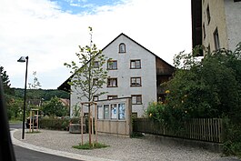
Effingen
| Effingen | ||
|---|---|---|
 |
||
|
||
| Coordinates: 47°30′N 8°6′E / 47.500°N 8.100°ECoordinates: 47°30′N 8°6′E / 47.500°N 8.100°E | ||
| Country | Switzerland | |
| Canton | Aargau | |
| District | Brugg | |
| Area | ||
| • Total | 6.85 km2 (2.64 sq mi) | |
| Elevation | 432 m (1,417 ft) | |
| Population (Dec 2015) | ||
| • Total | 613 | |
| • Density | 89/km2 (230/sq mi) | |
| Postal code | 5078 | |
| SFOS number | 4096 | |
| Surrounded by | Bözen, Elfingen, Gallenkirch, Linn, Mönthal, Oberbözberg, Unterbözberg, Zeihen | |
| Website |
www SFSO statistics |
|
Effingen is a municipality in the district of Brugg in canton of Aargau in Switzerland.
Effingen is first mentioned in 1284 as Efingen though the area was settled earlier. The earliest evidence of a settlement is a High Middle Ages chapel with associated Alamanni graves.
Effingen belonged to the court of Elfingen until 1460 when it was purchased by Bern. Under Bern it belonged to the court of Bözen of the Schenkenberg Bailiwick. By 1550 the village administrative rights were limited and in 1614 village officials were first mentioned.
Effingen's chapel belonged to the parish of Elfingen and after 1600 to the parish of Bözen. By no later than 1684 there was a village school.
Until the 19th century agriculture prevailed with wine being the most important product. In the 18th century home processing of cotton brought another industry to the village. The village has had a tavern since the 13th century, which provided a stopping point for traffic over the Bözberg and another source of income.
In 1777-79 a new road was built, which increased the traffic into the village. Then, in 1875, a railroad station was built in Effingen. In 1996, the A3 motorway was built near Effingen. Since about 1980 the village has been expanding with new construction. By 2000, the third sector of the economy accounted for about two thirds of jobs in Effingen.
Effingen has an area, as of 2006[update], of 6.85 square kilometers (2.64 sq mi). Of this area, 2.98 square kilometers (1.15 sq mi) or 43.5% is used for agricultural purposes, while3.23 square kilometers (1.25 sq mi) or 47.2% is forested. Of the rest of the land, 0.58 square kilometers (0.22 sq mi) or 8.5% is settled (buildings or roads), 0.05 km2 (12 acres) or 0.7% is either rivers or lakes and 0.03 km2 (7.4 acres) or 0.4% is unproductive land.
...
Wikipedia


