East Brunswick
| East Brunswick, New Jersey | |
|---|---|
| Township | |
| Township of East Brunswick | |

Typical suburban neighborhood (Dunhams Corner) in East Brunswick
|
|
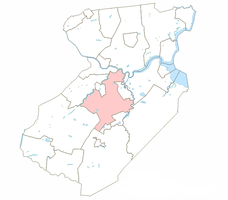
 Location of East Brunswick Township in Middlesex County. |
|
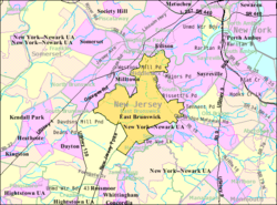
 Census Bureau map of East Brunswick, New Jersey |
|
| Coordinates: 40°25′34″N 74°25′06″W / 40.426247°N 74.418244°WCoordinates: 40°25′34″N 74°25′06″W / 40.426247°N 74.418244°W | |
| Country | |
| State |
|
| County | Middlesex |
| Incorporated | February 28, 1860 |
| Government | |
| • Type | Faulkner Act (Mayor-Council) |
| • Body | Township Council |
| • Mayor | Dr. Brad J. Cohen (D, term ends December 31, 2020) |
| • Administrator | Jack P. Layne Jr. |
| • Municipal clerk | Nennette Perry |
| Area | |
| • Total | 22.270 sq mi (57.679 km2) |
| • Land | 21.699 sq mi (56.200 km2) |
| • Water | 0.571 sq mi (1.479 km2) 2.56% |
| Area rank | 122nd of 566 in state 6th of 25 in county |
| Elevation | 131 ft (40 m) |
| Population (2010 Census) | |
| • Total | 47,512 |
| • Estimate (2016) | 48,630 |
| • Rank | 38th of 566 in state 7th of 25 in county |
| • Density | 2,189.6/sq mi (845.4/km2) |
| • Density rank | 276th of 566 in state 20th of 25 in county |
| Time zone | EST (UTC-5) |
| • Summer (DST) | Eastern (EDT) (UTC-5) |
| ZIP code | 08816 |
| Area code(s) | 732 |
| FIPS code | 3402319000 |
| GNIS feature ID | 0882163 |
| Website | www |
East Brunswick is a township in Middlesex County, New Jersey, United States. The suburban community is part of the New York City metropolitan area and is located on the southern shore of the Raritan River, directly adjacent to the city of New Brunswick. According to the 2010 United States Census, the township's population was 47,512, reflecting an increase of 756 (+1.6%) from the 46,756 counted in the 2000 Census, which had in turn increased by 3,208 (+7.4%) from the 43,548 counted in the 1990 Census.
East Brunswick was incorporated as a township by an act of the New Jersey Legislature on February 28, 1860, from portions of both Monroe Township and North Brunswick Township. Portions of the township were taken to form Washington town within the township (February 23, 1870; became independent as South River on February 28, 1898), Helmetta (March 20, 1888), Milltown (January 29, 1889) and Spotswood (April 15, 1908).
As of the 2010 Census, the United States Census Bureau calculated that New Jersey's center of population was located a few hundred feet east of Nenninger Lane, near the New Jersey Turnpike. Based on the results of the 2000 Census, the state's center of population was located on Milltown Road in East Brunswick.
...
Wikipedia
