Spotswood, New Jersey
| Spotswood, New Jersey | |
|---|---|
| Borough | |
| Borough of Spotswood | |
 Spotswood highlighted in Middlesex County |
|
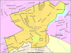
 Census Bureau map of Spotswood, New Jersey |
|
| Coordinates: 40°23′44″N 74°23′24″W / 40.395687°N 74.390089°WCoordinates: 40°23′44″N 74°23′24″W / 40.395687°N 74.390089°W | |
| Country |
|
| State |
|
| County | Middlesex |
| Incorporated | May 12, 1908 |
| Government | |
| • Type | Faulkner Act (Mayor-Council) |
| • Body | Borough Council |
| • Mayor | Nicholas Poliseno (term ends December 31, 2016) |
| • Administrator | Dawn McDonald |
| • Clerk | Patricia DeStefano |
| Area | |
| • Total | 2.472 sq mi (6.402 km2) |
| • Land | 2.267 sq mi (5.872 km2) |
| • Water | 0.205 sq mi (0.531 km2) 8.29% |
| Area rank | 375th of 566 in state 20th of 25 in county |
| Elevation | 36 ft (11 m) |
| Population (2010 Census) | |
| • Total | 8,257 |
| • Estimate (2015) | 8,476 |
| • Rank | 278th of 566 in state 20th of 25 in county |
| • Density | 3,642.2/sq mi (1,406.3/km2) |
| • Density rank | 175th of 566 in state 13th of 25 in county |
| Time zone | Eastern (EST) (UTC-5) |
| • Summer (DST) | Eastern (EDT) (UTC-4) |
| ZIP code | 08884 |
| Area code(s) | 732 Exchanges: 251.416,723 |
| FIPS code | 3402369810 |
| GNIS feature ID | 0885405 |
| Website | spotswoodboro |
Spotswood is a borough in Middlesex County, New Jersey, United States. As of the 2010 United States Census, the borough's population was 8,257, reflecting an increase of 377 (+4.8%) from the 7,880 counted in the 2000 Census, which had in turn declined by 103 (−1.3%) from the 7,983 counted in the 1990 Census.
Its first settler James Johnston originally called the place "Spottiswoode", named for his old place of residence in Scotland, and dates back to its original settlement in 1685.
Spotswood was incorporated as a borough by an act of the New Jersey Legislature on April 15, 1908, from portions of East Brunswick Township, based on the passage of a referendum held on May 12, 1908.
According to the United States Census Bureau, the borough had a total area of 2.472 square miles (6.402 km2), including 2.267 square miles (5.872 km2) of land and 0.205 square miles (0.531 km2) of water (8.29%). To the north east edge lies Duhernal Lake.
Unincorporated communities, localities and place names located partially or completely within the township include Outcalt, which is located along the border of Spotswood and Monroe Township.
The borough borders the Middlesex County municipalities of East Brunswick Township, Helmetta, Monroe Township and Old Bridge Township.
The 2010 United States Census counted 8,257 people, 3,128 households, and 2,143 families residing in the borough. The population density was 3,642.2 per square mile (1,406.3/km2). The borough contained 3,242 housing units at an average density of 1,430.1 per square mile (552.2/km2). The racial makeup of the borough was 88.63% (7,318) White, 2.98% (246) Black or African American, 0.11% (9) Native American, 5.14% (424) Asian, 0.01% (1) Pacific Islander, 1.27% (105) from other races, and 1.87% (154) from two or more races. Hispanics or Latinos of any race were 8.32% (687) of the population.
...
Wikipedia
