East Amwell Township, New Jersey
| East Amwell Township, New Jersey | |
|---|---|
| Township | |
| Township of East Amwell | |

Old Presbyterian church in Reaville Historic District
|
|
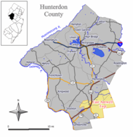
 Map of East Amwell Township in Hunterdon County. Inset: Location of Hunterdon County in the State of New Jersey. |
|
 Census Bureau map of East Amwell Township, New Jersey |
|
| Coordinates: 40°26′06″N 74°49′23″W / 40.434993°N 74.82303°WCoordinates: 40°26′06″N 74°49′23″W / 40.434993°N 74.82303°W | |
| Country | |
| State |
|
| County | Hunterdon |
| Incorporated | April 6, 1846 |
| Named for | Amwell Township / Amwell, Hertfordshire |
| Government | |
| • Type | Township (New Jersey) |
| • Body | Township Committee |
| • Mayor | David Wang-Iverson (D, term ends December 31, 2016) |
| • Administrator | Timothy L. Matheny |
| • Clerk | Terri Stahl |
| Area | |
| • Total | 28.561 sq mi (73.972 km2) |
| • Land | 28.459 sq mi (73.707 km2) |
| • Water | 0.102 sq mi (0.264 km2) 0.36% |
| Area rank | 94th of 566 in state 8th of 26 in county |
| Elevation | 203 ft (62 m) |
| Population (2010 Census) | |
| • Total | 4,013 |
| • Estimate (2015) | 3,925 |
| • Rank | 413th of 566 in state 11th of 26 in county |
| • Density | 141.0/sq mi (54.4/km2) |
| • Density rank | 529th of 566 in state 23rd of 26 in county |
| Time zone | Eastern (EST) (UTC-5) |
| • Summer (DST) | Eastern (EDT) (UTC-4) |
| ZIP code | 08551 - Ringoes 08559 - |
| Area code(s) | 609 and 908 |
| FIPS code | 3401918820 |
| GNIS feature ID | 0882180 |
| Website | www |
East Amwell Township is a township in Hunterdon County, New Jersey, United States. As of the 2010 United States Census, the township's population was 4,013, reflecting a decline of 442 (-9.9%) from the 4,455 counted in the 2000 Census, which had in turn increased by 123 (+2.8%) from the 4,332 counted in the 1990 Census.
East Amwell Township is located in the southeastern corner of Hunterdon County where it borders both Somerset and Mercer counties. It includes the unincorporated community of Ringoes, the oldest known settlement in Hunterdon County, as well as the communities of Larison's Corner, Weert's Corner and part of Reaville.
Amwell Township was established by a royal patent from Queen Anne in 1708. Its territory comprised 200 square miles (520 km2) and included present day Delaware Township, Raritan Township, Readington Township, East Amwell Township and West Amwell Township and portions of Clinton, Lebanon and Tewksbury Townships. Both East Amwell Township and West Amwell Township were formed on April 6, 1846, when Amwell Township was split in two. Territory was gain in 1854 from Delaware Township, Raritan Township and West Amwell Township, and again from those same three townships in 1897. The township was named for Amwell Township, which in turn was named for Amwell, Hertfordshire in England.
...
Wikipedia
