West Amwell Township, New Jersey
| West Amwell Township, New Jersey | |
|---|---|
| Township | |
| Township of West Amwell | |

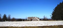
West Amwell Township Municipal Building
|
|
 Map of West Amwell Township in Hunterdon County. Inset: Location of Hunterdon County highlighted in the State of New Jersey. |
|
 Census Bureau map of West Amwell Township, New Jersey |
|
| Coordinates: 40°22′45″N 74°53′16″W / 40.379051°N 74.887735°WCoordinates: 40°22′45″N 74°53′16″W / 40.379051°N 74.887735°W | |
| Country |
|
| State |
|
| County | Hunterdon |
| Incorporated | April 6, 1846 |
| Named for | Amwell Township / Amwell, Hertfordshire |
| Government | |
| • Type | Township |
| • Body | Township Committee |
| • Mayor | Zachary T. Rich (R, term ends December 31, 2016) |
| • Clerk | Lora L. Olsen |
| Area | |
| • Total | 21.776 sq mi (56.398 km2) |
| • Land | 21.581 sq mi (55.894 km2) |
| • Water | 0.195 sq mi (0.505 km2) 0.89% |
| Area rank | 129th of 566 in state 12th of 26 in county |
| Elevation | 315 ft (96 m) |
| Population (2010 Census) | |
| • Total | 3,840 |
| • Estimate (2015) | 2,780 |
| • Rank | 420th of 566 in state 15th of 26 in county |
| • Density | 177.9/sq mi (68.7/km2) |
| • Density rank | 517th of 566 in state 22nd of 26 in county |
| Time zone | Eastern (EST) (UTC-5) |
| • Summer (DST) | Eastern (EDT) (UTC-4) |
| ZIP code | 08530 - Lambertville |
| Area code(s) | 609 |
| FIPS code | 3401978230 |
| GNIS feature ID | 0882181 |
| Website | www |
West Amwell Township is a township in Hunterdon County, New Jersey, United States. As of the 2010 United States Census, the township's population was 3,840, reflecting an increase of 1,457 (+61.1%) from the 2,383 counted in the 2000 Census, which had in turn increased by 132 (+5.9%) from the 2,251 counted in the 1990 Census.
West Amwell was incorporated as a township by an act of the New Jersey Legislature on April 6, 1846, when Amwell Township was split, also creating East Amwell Township at the same time. Portions of the township were taken to form Lambertville town on March 1, 1849. In 1896, the township annexed portions of Delaware Township, East Amwell Township and Raritan Township. The township was named for Amwell Township, which in turn was named for Amwell, Hertfordshire in England.
The Delaware Native Americans had a path through the woods from Lambertville through Mount Airy, Ringoes and Reaville to Newark upon which the Old York Road was subsequently laid.
The northern areas of West Amwell are in Amwell Valley, while the southern sections are in The Sourlands region. The Delaware River separates West Amwell from the Commonwealth of Pennsylvania.
...
Wikipedia
