Diboll, Texas
| Diboll, Texas | |
|---|---|
| City | |

T.L.L. Temple Memorial Library
|
|
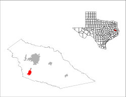
 Location of Diboll, Texas |
|
 |
|
| Coordinates: 31°11′10″N 94°47′7″W / 31.18611°N 94.78528°WCoordinates: 31°11′10″N 94°47′7″W / 31.18611°N 94.78528°W | |
| Country | United States |
| State | Texas |
| County | Angelina |
| Area | |
| • Total | 4.7 sq mi (12.3 km2) |
| • Land | 4.7 sq mi (12.2 km2) |
| • Water | 0.04 sq mi (0.1 km2) |
| Elevation | 210 ft (64 m) |
| Population (2010) | |
| • Total | 5,359 |
| • Density | 1,100/sq mi (440/km2) |
| Time zone | Central (CST) (UTC-6) |
| • Summer (DST) | CDT (UTC-5) |
| ZIP code | 75941 |
| Area code(s) | 936 |
| FIPS code | 48-20308 |
| GNIS feature ID | 1381758 |
| Website | www |
Diboll /ˈdaɪbɒl/ is a city in Angelina County, Texas, United States. The population was 5,359 at the 2010 census. Diboll is named for J. C. Diboll, a local timber salesman.
Diboll is located in southwestern Angelina County at 31°11′10″N 94°47′7″W / 31.18611°N 94.78528°W (31.186060, -94.785395).U.S. Route 59 (future Interstate 69) passes through the city, leading north 11 miles (18 km) to Lufkin, the county seat, and south 109 miles (175 km) to Houston.
According to the United States Census Bureau, the city has a total area of 4.7 square miles (12.3 km2), of which 4.7 square miles (12.2 km2) is land and 0.04 square miles (0.1 km2), or 1.20%, is water.
As of the census of 2000, there were 5,470 people, 1,424 households, and 1,107 families residing in the city. The population density was 1,141.9 people per square mile (440.9/km²). There were 1,582 housing units at an average density of 330.3 per square mile (127.5/km²). The racial makeup of the city was 53.67% White, 24.13% African American, 0.53% Native American, 0.05% Asian, 0.05% Pacific Islander, 19.40% from other races, and 2.16% from two or more races. Hispanic or Latino of any race were 37.26% of the population.
...
Wikipedia
