Damascus, Oregon
| Damascus | |
|---|---|
| Unincorporated community | |
| Damascus, Oregon | |

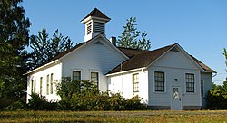
Old Damascus schoolhouse
|
|
 Location in Oregon |
|
| Coordinates: 45°25′48″N 122°26′47″W / 45.43000°N 122.44639°WCoordinates: 45°25′48″N 122°26′47″W / 45.43000°N 122.44639°W | |
| Country | United States |
| State | Oregon |
| County | Clackamas County |
| Incorporated | 2004 |
| Disincorporated | 2016 |
| Area | |
| • Total | 16.14 sq mi (41.80 km2) |
| • Land | 16.04 sq mi (41.54 km2) |
| • Water | 0.10 sq mi (0.26 km2) |
| Elevation | 712 ft (217 m) |
| Population (2010) | |
| • Total | 10,539 |
| • Estimate (2013) | 10,743 |
| • Density | 657.0/sq mi (253.7/km2) |
| Time zone | Pacific (UTC-8) |
| • Summer (DST) | Pacific (UTC-7) |
| ZIP codes | 97009, 97015, 97030, 97080, 97089 |
| Area code(s) | 503 and 971 |
| Elevation from U.S.G.S. | |
Damascus /dəˈmæskɪs/ is an unincorporated community and former city in Clackamas County, Oregon, United States. First incorporated in 2004 it was disincorporated July 18, 2016 upon voters' decision on May 17, 2016. Damascus is located east of Happy Valley and Interstate 205 and west of Boring. The area that later became the city had a population of 9,022 in 2000. The population was 10,539 residents as of the 2010 census.
According to Oregon Geographic Names, Damascus can date its existence as a community back to 1867, when a post office by that name was established. That post office was closed in 1904. The original heart of the community is along Oregon Route 212, which as of 2004 served as part of the city's southern boundary.
A 2000 decision by Metro to expand Portland's urban growth boundary into the area prompted some citizens of the community to submit Measure 3-138, a measure on the ballot for the 2004 general election in November. The initiative's passage resulted in the incorporation of the former unincorporated communities of Damascus and Carver into the City of Damascus, a step which prevents nearby cities from annexing the community. The city was the first new city in Oregon in 22 years.
...
Wikipedia
