Interstate 205 (Oregon)
| Interstate 205 | |||||||||
|---|---|---|---|---|---|---|---|---|---|
 |
|||||||||
| Route information | |||||||||
| Length: | 37.13 mi (59.75 km) | ||||||||
| Existed: | 1975 – present | ||||||||
| Major junctions | |||||||||
| South end: |
|
||||||||
|
|
|||||||||
| North end: |
|
||||||||
| Highway system | |||||||||
|
|||||||||
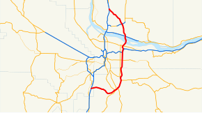
Interstate 205 (I-205) is a loop route that serves the Portland—Vancouver metropolitan area in the U.S. states of Oregon and Washington. I-205 is officially named the War Veterans Memorial Freeway in both states, and is known as the East Portland Freeway No. 64 in Oregon (see Oregon highways and routes). I-205 passes east of downtown Portland and Vancouver, thus serving as a bypass route of I-5, which runs directly through the downtown areas of both cities. The northern terminus of the highway is located north of Vancouver in the suburb of Salmon Creek, and the southern terminus is in the Portland suburb of Tualatin.
I-205 starts in Tualatin, Oregon, at a semi-directional T interchange with I-5. From I-5, the highway heads east towards the towns of West Linn and Oregon City where it crosses the Willamette River between interchanges for Oregon Route 43 (OR 43) and OR 99E. In West Linn, there is a view point exit for the northbound lanes, providing a scenic overlook of Willamette Falls. In Oregon City, the highway curves northward, crossing the Clackamas River concurrent with OR 213 and entering the town of Gladstone.
...
Wikipedia

