Happy Valley, Oregon
| Happy Valley, Oregon | |
|---|---|
| City | |

Happy Valley, on the southeast flank of Mount Scott
|
|
 Location in Oregon |
|
| Coordinates: 45°26′45″N 122°32′1″W / 45.44583°N 122.53361°WCoordinates: 45°26′45″N 122°32′1″W / 45.44583°N 122.53361°W | |
| Country | United States |
| State | Oregon |
| County | Clackamas |
| Incorporated | 1965 |
| Government | |
| • Mayor | Lori DeRemer |
| Area | |
| • Total | 8.32 sq mi (21.55 km2) |
| • Land | 8.28 sq mi (21.45 km2) |
| • Water | 0.04 sq mi (0.10 km2) |
| Elevation | 497 ft (151.5 m) |
| Population (2010) | |
| • Total | 13,903 |
| • Estimate (2013) | 16,321 |
| • Density | 1,679.1/sq mi (648.3/km2) |
| Time zone | Pacific (UTC-8) |
| • Summer (DST) | Pacific (UTC-7) |
| ZIP code | 97086 |
| Area code(s) | 503 and 971 |
| FIPS code | 41-32050 |
| GNIS feature ID | 1136354 |
| Website | www.happyvalleyor.gov |
Happy Valley is a city in Clackamas County, Oregon, United States. The population was 13,903 at the 2010 census.
Happy Valley was originally called Christilla Valley, named after the first residents, Christian and Matilda Deardorff. They arrived in 1851 and claimed 640 acres (2.6 km2) on the floor of the valley.
The city was officially incorporated in 1965 and remained a small community until the late 1990s, when it was one of the fastest-growing cities in Oregon.
The city has a mayor, Lori DeRemer, along with four other city council members. There is also a planning commission, as well as a Park Advisory/Urban Forestry Commission and Citizen Traffic and Public Safety Committee.
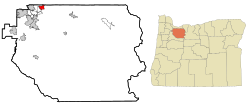
According to the United States Census Bureau, the city has a total area of 8.32 square miles (21.55 km2), of which, 8.28 square miles (21.45 km2) is land and 0.04 square miles (0.10 km2) is water. It is a member of the Portland, Oregon metropolitan area, bordering Portland, Clackamas, Damascus, Pleasant Valley, and Sunnyside.
Mount Scott, an extinct volcano that is part of the Boring Lava Field, is the highest point in Happy Valley at 1,050 feet (320 m). Scouters Mountain is also a prominent feature.
As of the census of 2010, there were 13,903 people, 4,408 households, and 3,724 families residing in the city. The population density was 1,679.1 inhabitants per square mile (648.3/km2). There were 4,708 housing units at an average density of 568.6 per square mile (219.5/km2). The ethnic makeup of the city was 76.2% White, 1.1% African American, 0.5% Native American, 17.4% Asian, 0.2% Pacific Islander, 0.9% from other ethnicities, and 3.8% from two or more ethnicities. Hispanic or Latino of any ethnicity were 4.0% of the population.
...
Wikipedia
