Cross Island Line
|
CRL Cross Island MRT Line Laluan MRT Rentas Pulau 跨岛地铁线 குறுக்கு தீவு மெட்ரோ வரி |
|
|---|---|

The Cross Island Line's colour and route are not confirmed.
|
|
| Overview | |
| Type | Rapid transit |
| System | Mass Rapid Transit (Singapore) |
| Status | Planning |
| Stations | 30 (estimated) |
| Daily ridership | 600,000 (expected) |
| Operation | |
| Opened | 2030 |
| Owner | Land Transport Authority |
| Operator(s) | TBA |
| Technical | |
| Line length | 50 km (31 mi) |
| Track gauge | 4 ft 8 1⁄2 in (1,435 mm) |
The Cross Island MRT Line (CRL) will be the eighth Mass Rapid Transit (MRT) line in Singapore. It is currently under planning and evaluation.
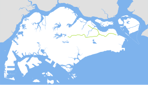
The line will begin from Changi, passing through Loyang, Pasir Ris, Hougang, Ang Mo Kio, Bukit Timah, Clementi, West Coast before terminating at Jurong Industrial Estate.
The line was first announced by the Land Transport Authority on 17 January 2013.
There has been a controversy over the alignment of the line's Bukit Timah stretch as it appears to cut through part of the Central Catchment Nature Reserve (CCNR) and MacRitchie Reservoir, although the Land Transport Authority insisted that the alignment of the line was not finalised as soil investigations and feasibility studies have yet to be conducted.
Targeted to be completed by 2030, it will offer East-West commuters an alternative to the existing East West Line. It will also connect to all the other major lines to serve as a key transfer line, complementing the role currently fulfilled by the orbital Circle Line.
The eastern leg of the line will include a segment that branches out from Pasir Ris and extends into Punggol.
Based on the Ministry of National Development Land Use Plan, this line is expected to interchange with the East West Line at Clementi and Pasir Ris, Downtown Line at King Albert Park MRT Station on Stage 2 (DTL2), Thomson-East Coast Line at Bright Hill, North South Line at Ang Mo Kio, and the North East Line at Hougang and Punggol.
...
Wikipedia
