Cophes
| Kabul | |
| River | |
| Country | Afghanistan & Pakistan |
|---|---|
| Tributaries | |
| - left | Panjshir River, Kunar River, Alingar River, Swat River |
| - right | Logar River, Bara River |
| Source | Hindu Kush Mountains |
| - elevation | 2,400 m (7,874 ft) |
| Mouth | Indus River |
| - location | |
| Length | 700 km (435 mi) |
| Basin | 66,000 km2 (25,483 sq mi) |
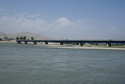
The Kabul River (Pashto: کابل سیند,Persian: دریای کابل;Urdu: دریائے کابل ), the classical Cophes /ˈkoʊfiːz/, is a 700-kilometre (430 mi) long river that emerges in the Sanglakh Range of the Hindu Kush mountains in Afghanistan and empties into the Indus River near , Pakistan. It is the main river in eastern Afghanistan and is separated from the watershed of the Helmand by the Unai Pass. The Kabul River passes through the cities of Kabul and Jalalabad in Afghanistan before flowing into Khyber Pakhtunkhwa in Pakistan some 25 kilometres (16 mi) north of the Durand Line border crossing at Torkham. The major tributaries of the Kabul River are the Logar, Panjshir, Kunar, Alingar, Bara and Swat rivers.
The Kabul River is little more than a trickle for most of the year, but swells in summer due to melting snows in the Hindu Kush Range. Its largest tributary is the Kunar River, which starts out as the Mastuj River, flowing from the Chiantar glacie in Brughil valley in Chitral, Pakistan and after flowing south into Afghanistan it is met by the Bashgal river flowing from Nurestan. The Kunar meets the Kabul near Jalalabad. In spite of the Kunar carrying more water than the Kabul, the river continues as the Kabul River after this confluence, mainly for the political and historical significance of the name.
...
Wikipedia

