Nurestan Province
|
Nuristan نورستان |
|
|---|---|
| Province | |

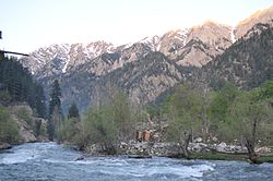
A river in Nuristan province
|
|
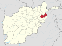
 Map of Afghanistan with Nuristan highlighted |
|
| Coordinates: 35°15′N 70°45′E / 35.25°N 70.75°ECoordinates: 35°15′N 70°45′E / 35.25°N 70.75°E | |
| Country |
|
| Provincial center | Parun |
| Government | |
| • Governor | Hafiz Abdul Qayyum |
| Area | |
| • Total | 9,225.0 km2 (3,561.8 sq mi) |
| Population | |
| • Total | 140,900 |
| • Density | 15/km2 (40/sq mi) |
| Time zone | GMT+4:30 |
| ISO 3166 code | AF-NUR |
| Main languages | Nuristani |
Nuristan, also spelled Nurestan or Nooristan, (Nuristani/Pashto: نورستان) is one of the 34 provinces of Afghanistan, located in the eastern part of the country. It is divided into seven districts and has a population of about 140,900.Parun serves as the provincial capital.
It was formerly known as Kafiristan (کافرستان, "land of the infidels") until the inhabitants were converted from a form of ancient Hinduism, to Islam in 1895, and thence the region has become known as Nuristan ("land of illumination").
The primary occupations are agriculture, animal husbandry, and day labor. Located on the southern slopes of the Hindu Kush mountains in the northeastern part of the country, Nuristan spans the basins of the Alingar, Pech, Landai Sin, and Kunar rivers. Nuristan is bordered on the south by Laghman and Kunar provinces, on the north by Badakhshan province, on the west by Panjshir province, and on the east by Khyber Pakhtunkhwa, Pakistan.
The surrounding area fell to Alexander the Great in 330 B.C. It later fell to Chandragupta Maurya. The Mauryas introduced Buddhism to the region, and were attempting to expand their empire to Central Asia until they faced local Greco-Bactrian forces. Seleucus is said to have reached a peace treaty with Chandragupta by giving control of the territory south of the Hindu Kush to the Mauryas upon intermarriage and 500 elephants.
...
Wikipedia
