Copeland Creek
| Copeland Creek | |
| perennial stream | |
|
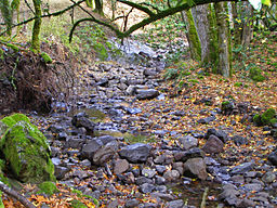
Copeland Creek with basalt armor in channel, Fairfield Osborn Preserve
|
|
| Country | United States |
|---|---|
| State | California |
| Region | Sonoma County |
| Cities | Penngrove, California, Rohnert Park, California |
| Source | |
| - location | Sonoma Mountain |
| - coordinates | 38°19′52″N 122°34′38″W / 38.33111°N 122.57722°W |
| Mouth | Laguna de Santa Rosa |
| - location | west of Rohnert Park, California |
| - elevation | 92 ft (28 m) |
| - coordinates | 38°20′37″N 122°43′25″W / 38.34361°N 122.72361°WCoordinates: 38°20′37″N 122°43′25″W / 38.34361°N 122.72361°W |
Copeland Creek is a 9.0-mile-long (14.5 km)perennial stream that rises on Sonoma Mountain in Sonoma County, California.
The headwaters area is slightly above the Fairfield Osborn Preserve, while the middle reaches drain grazing land and vineyards on the lower western slopes of the Sonoma Mountains. Upon reaching the valley floor Copeland Creek bisects the campus of Sonoma State University on its journey to discharge into the Laguna de Santa Rosa. The Copeland Creek watershed is part of the Russian River basin, which drains to the Pacific Ocean.
The prehistory of this watershed and creek environment includes settlement by Coast Miwok, Wappo and Pomo peoples. These hunter gatherers dominated human usage until arrival of Europeans in the early 19th century. Rather swiftly an overgrazing situation arose not only in the lower reaches, but as high as the present Fairfield Osborn Preserve, which extends to elevation 1,700 feet (520 m). The upper reaches of the creek were effectively restored, following the purchase of the present lands of the Fairfield Osborn Preserve by William Matson Roth.
The lower reaches were heavily disturbed as late as the 1990s, when a restoration of the reach between Roberts Road and Petaluma Hill Road was started. These lower reaches would have been historically heavily vegetated by native alder and arroyo willow. However, cattle grazing and associated trampling of vegetation severely reduced spawning of anadromous fish: by altering stream cover that cooled water temperatures and by elevating turbidity, with resulting covering of spawning gravels. Some lower reaches between Roberts Road and the Fairfield Osborn Preserve are still subject to overgrazing as of 2006. Overgrazing has also exacerbated stream bank erosion, and led to invasive forbs and grasses supplanting the native riparian vegetation. This alteration of native riparian growth has further reduced populations of avafauna, amphibians and macro invertebrates.
...
Wikipedia

