Russian River (California)
| Russian River (Ashokawna or Bidapte) | |
| Slavianka River Rio San Ygnacio, Rio San Ignacio |
|
| River | |
|
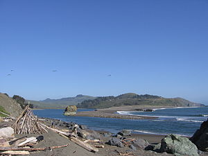
The estuary of the Russian River, north of Bodega Bay
|
|
| Country | United States |
|---|---|
| State | California |
| Regions | Sonoma County, Mendocino County |
| Tributaries | |
| - left | Mark West Creek, Maacama Creek, Green Valley Creek, Big Sulphur Creek |
| - right | Dry Creek, Austin Creek, Fife Creek |
| Cities | Ukiah, Healdsburg |
| Source | Laughlin Range |
| - location | 5 mi (8 km) east of Willits, California |
| - elevation | 1,960 ft (597 m) |
| - coordinates | 39°23′0″N 123°14′18″W / 39.38333°N 123.23833°W |
| Mouth | Pacific Ocean |
| - location | Jenner, California |
| - elevation | 0 ft (0 m) |
| - coordinates | 38°27′2″N 123°7′46″W / 38.45056°N 123.12944°WCoordinates: 38°27′2″N 123°7′46″W / 38.45056°N 123.12944°W |
| Length | 110 mi (177 km) |
| Basin | 1,485 sq mi (3,846 km2) |
| Discharge | for Guerneville |
| - average | 2,261 cu ft/s (64.0 m3/s) |
| - max | 102,000 cu ft/s (2,888.3 m3/s) |
| - min | 0.75 cu ft/s (0.0 m3/s) |
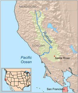
The Russian River, a southward-flowing river, drains 1,485 square miles (3,846 km2) of Sonoma and Mendocino counties in Northern California. With an annual average discharge of approximately 1,600,000 acre feet (2.0 km3), it is the second-largest river (after the Sacramento River) flowing through the nine-county Greater San Francisco Bay Area, with a mainstem 110 miles (177 km.) long.
The Russian River springs from the Laughlin Range about 5 mi (8 km) east of Willits in Mendocino County. It flows generally southward to Redwood Valley, then past Calpella, where it is bordered by U.S. Route 101, to join the East Fork Russian River just below Lake Mendocino.
From there the Russian River flows south, past Ukiah and Hopland, and crosses into Sonoma County just north of Cloverdale. Closely paralleled by U.S. Route 101, it descends into the Alexander Valley, where it is joined by Big Sulphur Creek. It flows south past Cloverdale, Asti, and Geyserville.
East of Healdsburg, Maacama Creek joins the Russian River. After it makes a series of sweeping bends, the Healdsburg Memorial Bridge carries Old Redwood Highway over the river just upstream of U.S. Route 101's Healdsburg crossing. It receives water from Lake Sonoma via Dry Creek. The river turns westward, where it is spanned by the Wohler Bridge, and it is joined by Mark West Creek north of Forestville, followed by Green Valley Creek to the south. The river passes Rio Nido and Guerneville. In that area, State Route 116 parallels the river, bordering it past Guernewood Park and Monte Rio.
...
Wikipedia


