Ukiah, California
| Ukiah, California | |
|---|---|
| City | |
| City of Ukiah | |
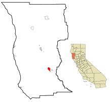
 Location in Mendocino County and the State of California |
|
| Coordinates: 39°09′01″N 123°12′28″W / 39.15028°N 123.20778°WCoordinates: 39°09′01″N 123°12′28″W / 39.15028°N 123.20778°W | |
| Country | United States |
| State | California |
| County | Mendocino |
| Incorporated | March 8, 1876 |
| Government | |
| • Type | Council/Manager |
| • Mayor | Jim Brown |
| • City manager | Sage Sangiacomo |
| Area | |
| • Total | 4.722 sq mi (12.232 km2) |
| • Land | 4.670 sq mi (12.096 km2) |
| • Water | 0.052 sq mi (0.136 km2) 1.11% |
| Elevation | 633 ft (193 m) |
| Population (April 1, 2010) | |
| • Total | 16,075 |
| • Estimate (2013) | 15,871 |
| • Density | 3,400/sq mi (1,300/km2) |
| Time zone | Pacific (UTC−8) |
| • Summer (DST) | PDT (UTC−7) |
| ZIP codes | 95482 and 95418 |
| Area code | 707 |
| FIPS code | 06-81134 |
| GNIS feature IDs | 277623, 2412125 |
| Website | www |
Ukiah (/juːˈkaɪ.ə/ yew-KY-ə; formerly Ukiah City) is the county seat and largest city of Mendocino County, California. With its accessible location (along the U.S. Route 101 corridor several miles south of CA 20), Ukiah serves as the city center for Mendocino County and much of neighboring Lake County. The Ukiah Valley is a center of a major wine production industry. In 1996, Ukiah was ranked the #1 best small town to live in California and the sixth-best place to live in the United States. The population was 16,075 at the 2010 census.
Ukiah is located within Rancho Yokaya, one of several Spanish colonial land grants in what was then called "Alta California". The Yokaya grant, which covered the majority of the Ukiah valley, was named after the Pomo word meaning "deep valley." The Pomo were the indigenous people who occupied the area at the time of Spanish colonization. This word was also the basis for the city name, as Ukiah was an anglicized form of Yokaya.
The first Anglo settler to dwell proximate to today's Ukiah was John Parker, a vaquero who worked for pioneer cattleman James Black. Black had driven his stock up the Russian River valley and took possession of a block of grazing land at that locale; a crude block house was constructed to house Parker in order to protect him and the herd from the hostile indigenous local population. This block house was located just south of present-day Ukiah on the banks of what was known as Wilson Creek.
...
Wikipedia
