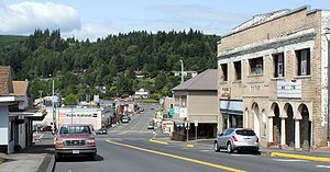
Clatskanie, Oregon
| Clatskanie, Oregon | |
|---|---|
| City | |

Downtown Clatskanie
|
|
 Location in Oregon |
|
| Coordinates: 46°6′11″N 123°12′13″W / 46.10306°N 123.20361°WCoordinates: 46°6′11″N 123°12′13″W / 46.10306°N 123.20361°W | |
| Country | United States |
| State | Oregon |
| County | Columbia |
| Incorporated | 1891 |
| Government | |
| • Mayor | Diane Pohl |
| Area | |
| • Total | 1.19 sq mi (3.08 km2) |
| • Land | 1.19 sq mi (3.08 km2) |
| • Water | 0 sq mi (0 km2) |
| Elevation | 59 ft (17.98 m) |
| Population (2010) | |
| • Total | 1,737 |
| • Estimate (2012) | 1,729 |
| • Density | 1,459.7/sq mi (563.6/km2) |
| Time zone | Pacific (UTC-8) |
| • Summer (DST) | Pacific (UTC-7) |
| ZIP code | 97016 |
| Area code(s) | 503 and 971 |
| FIPS code | 41-13750 |
| GNIS feature ID | 1118980 |
| Website | www.cityofclatskanie.com |
Clatskanie /ˈklætskᵻnaɪ/ is a city in Columbia County, Oregon, United States. It was named for the Clatskanie River, which empties into the Columbia River within the city limits. The population was 1,737 at the 2010 census.
According to some reports, the original name of this town when it was platted in 1884, was Bryantville. However, the post office in this location is shown as Clatskanie as early as December 1871.
Clatskanie comes from a Native American word, Tlatskani. According to the Clatsop County pioneer Silas B. Smith, Tlatskani was a point in the Nehalem River that was reached from the Columbia River by way of the Youngs River or by way of the Clatskanie River. The native inhabitants, who were not in the habit of naming streams, did not use the word Tlatskani for the streams they would follow in order to get to that point, but the white men who settled here later did apply the name to the streams.
Clatskanie is also the name of a Native American people, whose numbers dwindled from smallpox, intermittent fever, warfare, and intermarriage until they numbered only three people in a 1910 census.
Many of Clatskanie's inhabitants are of Nordic heritage, specifically Finnish, Swedish, and Norwegian.
...
Wikipedia
