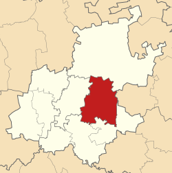
City of Ekurhuleni Metropolitan Municipality
| Ekurhuleni | ||
|---|---|---|
| City | ||
|
||
 Location in Gauteng |
||
| Coordinates: 26°13′7″S 28°09′46″E / 26.21861°S 28.16278°ECoordinates: 26°13′7″S 28°09′46″E / 26.21861°S 28.16278°E | ||
| Country | South Africa | |
| Province | Gauteng | |
| Seat | Germiston | |
| Wards | 101 | |
| Government | ||
| • Type | Municipal council | |
| • Mayor | Mzwandile Masina (ANC) | |
| Area | ||
| • Total | 1,975 km2 (763 sq mi) | |
| Population (2011) | ||
| • Total | 3,178,470 | |
| • Density | 1,600/km2 (4,200/sq mi) | |
| Racial makeup (2011) | ||
| • Black African | 78.7% | |
| • Coloured | 2.7% | |
| • Indian/Asian | 2.1% | |
| • White | 15.8% | |
| First languages (2011) | ||
| • Zulu | 28.8% | |
| • English | 12.0% | |
| • Afrikaans | 11.9% | |
| • Northern Sotho | 11.4% | |
| • Other | 35.9% | |
| Time zone | SAST (UTC+2) | |
| Municipal code | EKU | |
| Population pyramid 2011 | ||||
| % | Males | Age | Females | % |
| n/d | 85+ | n/d | ||
| n/d | 80–84 | n/d | ||
| 0.53 | 75–79 | 0.89 | ||
| 0.65 | 70–74 | 0.74 | ||
| 1.04 | 65–69 | 1.07 | ||
| 1.46 | 60–64 | 1.47 | ||
| 1.95 | 55–59 | 1.91 | ||
| 2.37 | 50–54 | 2.26 | ||
| 3.02 | 45–49 | 2.65 | ||
| 3.72 | 40–44 | 3.18 | ||
| 4.87 | 35–39 | 4.18 | ||
| 5.75 | 30–34 | 5.05 | ||
| 5.59 | 25–29 | 5.13 | ||
| 4.04 | 20–24 | 4.01 | ||
| 3.21 | 15–19 | 3.29 | ||
| 3.67 | 10–14 | 3.69 | ||
| 4.41 | 5–9 | 4.40 | ||
| 4.87 | 0–4 | 4.90 | ||
The City of Ekurhuleni Metropolitan Municipality is a metropolitan municipality that forms the local government of the East Rand region of Gauteng, South Africa. The name Ekurhuleni means place of peace in XiTsonga. Ekurhuleni is one of the five districts of Gauteng province and one of the eight metropolitan municipalities of South Africa. The seat of Ekurhuleni is Germiston. The largest language group among its 3.17 million people is IsiZulu (2001 Census). OR Tambo International Airport is in the Kempton Park area of Ekurhuleni.
Ekurhuleni lies on the plateau that is the highveld and is at about 1600 metres of altitude. The highest elevation can be found at the Giloolys ridge – Bill Stewart Side –Fishers hill 1772m asl The lowest point is at 1552m asl. The city is rich in wetlands, pans, streams and rivers. The city is highly urbanised, however the north especially has high potential agricultural land.
Ekurhuleni has a Cwb Climate according to the Köppen-Geiger Climate classification. This classifies a warm temperate climate of warm summers and dry winters. In the winter months (May - October) the city has a diurnal temperature pattern with a high amplitude, as temperatures can range from freezing at night to mid 20s°C within the day. The main precipitation falls between October and March with a monthly average precipitation of up to 148mm which falls usually in convective Thundershowers. The daily maximum temperatures in Oct-March are on average 27 °C. The Winter is mostly dry with only a few coldfronts reaching the highveld from the southern Atlantic Ocean.
...
Wikipedia

