Cibolo Creek
| Cibolo Creek | |
| Texas | |
|
Cibolo Creek in Boerne
|
|
| Country | United States |
|---|---|
| State | Texas |
| Source | Turkey Knob |
| - location | Boerne, Texas |
| - elevation | 623 m (2,044 ft) |
| - coordinates | 29°50′18″N 98°53′10″W / 29.83833°N 98.88611°W |
| Mouth | San Antonio River |
| - location | Helena, Texas |
| - elevation | 93 m (305 ft) |
| - coordinates | 28°57′11″N 97°52′24″W / 28.95306°N 97.87333°WCoordinates: 28°57′11″N 97°52′24″W / 28.95306°N 97.87333°W |
| Length | 154.497 km (96 mi) |
|
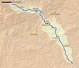
Map of the Cibolo Creek watershed
|
|
Cibolo Creek is a stream in South Central Texas, United States that runs approximately 96 miles (154 km) from its source at Turkey Knob (in the Texas Hill Country) near Boerne, Texas, to its confluence with the San Antonio River in Karnes County. The creek serves as a tributary of the San Antonio River and forms the easternmost boundary of its watershed.
The stream is used for both recreational and political purposes, serving as the eastern boundary of Bexar County, Texas. A wide variety of fish and other wildlife are known to occupy the waters, and several parks have been established along its banks, including Cibolo Nature Center, Boerne City Park and Jackson Nature Center. Additionally, numerous human settlements have been founded on the creek, such as Boerne, Fair Oaks Ranch, San Antonio, Bulverde, Bracken, Selma, Schertz, Universal City, Cibolo, Zuehl, New Berlin, La Vernia, Cestohowa, Kosciusko, Sutherland Springs and Panna Maria.
Cibolo Creek rises in the Texas Hill Country northwest of Boerne in Kendall County, Texas. Every second, approximately 30 cubic feet (850 L) of water pass through on its southeastern journey to the San Antonio River. It has been judged as a "scenic" and "picturesque" stream, especially in the upper reaches, as steady flows travel through deep canyons and rocky flats to form falls. Just ahead of its entry into Boerne, the stream is dammed to form Boerne City Lake, which provides drinking water for the town's residents. In Boerne, the creek flows through the center of town before reaching the Cibolo Nature Center, noted for its shores lined with bald cypress trees. East of the nature center, the Cibolo Canyonlands begin, which features even deeper canyons and direct groundwater recharge. Part of this area is protected by the University of Texas at San Antonio for environmental research purposes.
...
Wikipedia


