Universal City, Texas
| City of Universal City | |
|---|---|
| City | |

Randolph Air Force Base Chapel
|
|
| Motto: "The Gateway to Randolph AFB" | |
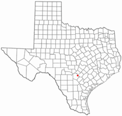
 Location of Universal City, Texas |
|
 |
|
| Coordinates: 29°33′10.381″N 98°18′27.274″W / 29.55288361°N 98.30757611°WCoordinates: 29°33′10.381″N 98°18′27.274″W / 29.55288361°N 98.30757611°W | |
| Country | United States |
| State | Texas |
| County | Bexar, Guadalupe |
| Government | |
| • Type | Council-Manager |
| • City Council |
Mayor John Williams Richard “Dick” Neville Tom Maxwell Beverly Volle Tom England S. Bear Goolsby William Shelby |
| • City Manager | Ken Taylor |
| Area | |
| • Total | 5.6 sq mi (14.6 km2) |
| • Land | 5.6 sq mi (14.6 km2) |
| • Water | 0.0 sq mi (0.0 km2) |
| Elevation | 764 ft (233 m) |
| Population (2000) | |
| • Total | 14,849 |
| • Density | 2,628.2/sq mi (1,014.7/km2) |
| Time zone | Central (CST) (UTC-6) |
| • Summer (DST) | CDT (UTC-5) |
| ZIP codes | 78148, 78150 |
| Area code(s) | 210, 726 (planned) |
| FIPS code | 48-74408 |
| GNIS feature ID | 1349101 |
| Website | www |
Universal City is a city located primarily in Bexar county, though slivers of its territory stretch into Guadalupe county,Texas, United States. It borders San Antonio to the northeast, and is adjacent to Randolph Air Force Base. The population was 18,530 at the 2010 census. It is part of the San Antonio Metropolitan Statistical Area.
Universal City was established in 1960. Through Universal City is Pat Booker Road, the commercial thoroughfare of the city.
The mean center of Universal City is located at 29°33′10.381″N 98°18′27.274″W / 29.55288361°N 98.30757611°W (29.552883698, -98.307576166). This is about 15 miles (24 km) northeast of Downtown San Antonio.
According to the United States Census Bureau, the city has a total area of 5.7 square miles (15 km2), all of it land.
As of the census of 2010, there were 18,530 people, 7,575 households, and 4,973 families residing in the city. The population density was 3,321.4 people per square mile (1,282.4/km²). There were 8,036 housing units at an average density of 1,120.5 per square mile (432.6/km²). The racial makeup of the city was 75.4% White, 10.1% African American, 0.70% Native American, 2.9% Asian, 0.3% Pacific Islander, 6.3% from other races, and 4.2% from two or more races. Hispanic or Latino of any race were 32.3% of the population.
...
Wikipedia
