Bulverde, Texas
| Bulverde, Texas | |
|---|---|
| City | |
| Motto: "Outhouse of the Texas Hill Country" | |
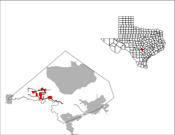
 Location of Bulverde, Texas |
|
 |
|
| Coordinates: 29°44′55″N 98°24′48″W / 29.74861°N 98.41333°WCoordinates: 29°44′55″N 98°24′48″W / 29.74861°N 98.41333°W | |
| Country | United States |
| State | Texas |
| County | Comal |
| Area | |
| • Total | 9.73 sq mi (25.20 km2) |
| • Land | 9.72 sq mi (25.17 km2) |
| • Water | 0.008 sq mi (0.02 km2) |
| Elevation | 1,093 ft (333 m) |
| Population (2010) | |
| • Total | 4,630 |
| • Density | 476/sq mi (183.9/km2) |
| Time zone | Central (CST) (UTC-6) |
| • Summer (DST) | CDT (UTC-5) |
| ZIP code | 78163 |
| Area code(s) | 830 |
| FIPS code | 48-11224 |
| GNIS feature ID | 1378070 |
| Website | bulverdetx |
Bulverde (/bʊlˈvɜːrdi/ bull-VER-dee) is a city in Comal County, Texas, United States. The population was 4,630 at the 2010 census, up from 3,761 at the 2000 census. It is part of the San Antonio Metropolitan Statistical Area.
Bulverde is located in western Comal County at 29°44′55″N 98°24′48″W / 29.748486°N 98.413238°W, about 26 miles (42 km) north of downtown San Antonio. U.S. Route 281 passes through the east side of Bulverde, leading south to San Antonio and north 25 miles (40 km) to Blanco. Cibolo Creek, which forms the Comal County/Bexar County line, runs just south of Bulverde.
According to the United States Census Bureau, the city has a total area of 9.7 square miles (25.2 km2), of which 0.01 square miles (0.02 km2), or 0.09%, is water.
...
Wikipedia
