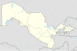
Chust, Uzbekistan
|
Chust Chust/Чуст |
|
|---|---|
| City | |
| Location in Uzbekistan | |
| Coordinates: 40°59′52″N 71°14′25″E / 40.99778°N 71.24028°ECoordinates: 40°59′52″N 71°14′25″E / 40.99778°N 71.24028°E | |
| Country |
|
| Region | Namangan Region |
| District | Chust District |
| City status | 1969 |
| Elevation | 1,100 m (3,600 ft) |
| Population (2004) | |
| • Total | 63,800 |
| Time zone | UZT (UTC+5) |
| • Summer (DST) | not observed (UTC+5) |
| Postal code | 161100 |
| Area code(s) | +998 6942 |
Chust (Uzbek: Chust/Чуст; Tajik: Чуст; Russian: Чуст) is a city in eastern Uzbekistan. It is the administrative center of Chust District. The City of Chust is located in the northern corner of the Fergana Valley along the river Chustsoy.
Chust is one of the oldest cities in the Fergana Valley. The Fergana automobile road passes through the city. This road connects Chust with several others places, such as the cities of Namangan, Andijan, and Fergana.
Chust underwent significant changes during the Soviet period. Many factories and institutions were built during that time. Currently, the city is an important center for cotton processing.
Chust is one of the oldest cities in the Fergana Valley. Archaeological studies conducted in 1953, 1957, 1959, and 1961 found items dating back to the late Bronze/early Iron age in the area corresponding to present-day Chust. First scientific information about Chust can be found in A. F. Middendor's Ocherki o Ferganskoy doline (Essays About the Fergana Valley) which was published in St. Petersburg in 1882. According to local linguists, the word "chust" is a Persian word meaning "fast."
In the Middle Ages, Chust became an important fortress. Babur's father Umar Shaikh Mirza II made Chust his residence in 1480. In the 16th century, the city consisted of several small fortresses. Later, a wall surrounding these fortresses was built. In 1882, the walls of the fortress were destroyed and the city started to expand.
...
Wikipedia

