Charlotte, Vermont
| Charlotte, Vermont | |
|---|---|
| Town | |

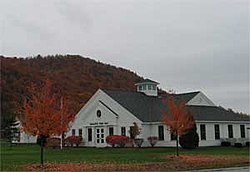
Charlotte town hall
|
|
 Location in Chittenden County and the state of Vermont. |
|
| Location in the United States | |
| Coordinates: 44°18′33″N 73°14′6″W / 44.30917°N 73.23500°WCoordinates: 44°18′33″N 73°14′6″W / 44.30917°N 73.23500°W | |
| Country | United States |
| State | Vermont |
| County | Chittenden |
| Area | |
| • Total | 50.3 sq mi (130.4 km2) |
| • Land | 41.3 sq mi (106.9 km2) |
| • Water | 9.1 sq mi (23.6 km2) |
| Elevation | 354 ft (108 m) |
| Population (2010) | |
| • Total | 3,754 |
| • Density | 91/sq mi (35.1/km2) |
| Time zone | Eastern (EST) (UTC-5) |
| • Summer (DST) | EDT (UTC-4) |
| ZIP code | 05445 |
| Area code(s) | 802 |
| FIPS code | 50-13300 |
| GNIS feature ID | 1462068 |
| Website | www |
Charlotte /ʃɑːrˈlɒt/ is a town in Chittenden County, Vermont, United States. The town was named for Sofia Charlotte of Mecklenburg-Strelitz, Queen of England and wife of King George III. The population of the town was 3,754 at the 2010 census.
Charlotte is located in the southwest corner of Chittenden County. It is bordered to the north by the town of Shelburne, to the east by Hinesburg, to the southeast by Monkton in Addison County, and to the south by Ferrisburgh in Addison County. To the west the town extends to the New York/Vermont border in the middle of Lake Champlain. According to the United States Census Bureau, the town has a total area of 50.3 square miles (130.4 km2), of which 41.3 square miles (106.9 km2) is land and 9.1 square miles (23.6 km2), or 18.08%, is water.
Charlotte is home to 990-foot-high (300 m) Mount Philo, within the state's first and most frequently visited state park. The park was established in 1924 and is open seasonally.
As of the census of 2000, there were 3,569 people, 1,287 households, and 990 families residing in the town. The population density was 86.0 people per square mile (33.2/km2). There were 1,500 housing units at an average density of 36.2 per square mile (14.0/km2). The racial makeup of the town was 97.93% White, 0.20% African American, 0.06% Native American, 0.59% Asian, 0.45% from other races, and 0.78% from two or more races. Hispanic or Latino of any race were 0.70% of the population.
...
Wikipedia

