Chambers County, TX
| Chambers County, Texas | |
|---|---|

The Chambers County Courthouse in Anahuac
|
|
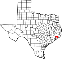
 Location in the U.S. state of Texas |
|
 Texas's location in the U.S. |
|
| Founded | 1858 |
| Seat | Anahuac |
| Largest city | Mont Belvieu |
| Area | |
| • Total | 871 sq mi (2,256 km2) |
| • Land | 597 sq mi (1,546 km2) |
| • Water | 274 sq mi (710 km2), 31% |
| Population | |
| • (2010) | 35,096 |
| • Density | 59/sq mi (23/km2) |
| Congressional districts | 14th, 36th |
| Time zone | Central: UTC−6/−5 |
| Website | www |
Chambers County is a county in the U.S. state of Texas. As of the 2010 census, the population was 35,096. The county seat is Anahuac.
Chambers County is included in the Houston-The Woodlands-Sugar Land, TX Metropolitan Statistical Area.
Mission Nuestra Señora de la Luz, a Spanish mission in Texas, was established in 1756 near what is now Wallisville.
Chambers County was founded in 1858. It is named for Thomas Jefferson Chambers, a major general in the Texas Revolution.
According to the U.S. Census Bureau, the county has a total area of 871 square miles (2,260 km2), of which 597 square miles (1,550 km2) is land and 274 square miles (710 km2) (31%) is water.
The south and southwestern parts of the county lie in the Galveston Bay Area on the shores of Trinity Bay and East Bay. A small portion of the southeastern area lies on the coast of the Gulf of Mexico.
As of the census of 2000, there were 26,031 people, 9,139 households, and 7,219 families residing in the county. The population density was 43 people per square mile (17/km2). There were 10,336 housing units at an average density of 17 per square mile (7/km2). The racial makeup of the county was 81.88% White, 9.77% Black or African American, 0.48% Native American, 0.67% Asian, 6.02% from other races, and 1.18% from two or more races. 10.79% of the population were Hispanic or Latino of any race.
...
Wikipedia
