Mont Belvieu, Texas
| Mont Belvieu, Texas | |
|---|---|
| City | |
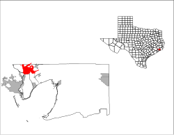
 Location of Mont Belvieu, Texas |
|
 |
|
| Coordinates: 29°51′37″N 94°52′28″W / 29.86028°N 94.87444°WCoordinates: 29°51′37″N 94°52′28″W / 29.86028°N 94.87444°W | |
| Country | United States |
| State | Texas |
| Counties | Chambers, Liberty |
| Area | |
| • Total | 15.3 sq mi (39.7 km2) |
| • Land | 15.0 sq mi (38.9 km2) |
| • Water | 0.3 sq mi (0.9 km2) |
| Elevation | 69 ft (21 m) |
| Population (2010) | |
| • Total | 3,835 |
| • Density | 256/sq mi (98.7/km2) |
| Time zone | Central (CST) (UTC-6) |
| • Summer (DST) | CDT (UTC-5) |
| ZIP code | 77580 |
| Area code(s) | 281 |
| FIPS code | 48-49068 |
| GNIS feature ID | 1341809 |
| Website | www |
Mont Belvieu is a city in Chambers and Liberty counties in the U.S. state of Texas. It is just north of Interstate 10 along State Highway 146. The population was 2,324 at the 2000 Census, increasing 65% to 3,835 in 2010.
Mont Belvieu is located in northwestern Chambers County at 29°51′37″N 94°52′28″W / 29.860242°N 94.874535°W (29.860242, -94.874535). A small part of the city limits extend north into Liberty County. The city is 14 miles (23 km) northeast of Baytown via Highway 146 and 31 miles (50 km) east of Houston via Interstate 10.
According to the United States Census Bureau, Mont Belvieu has a total area of 15.3 square miles (39.7 km2), of which 15.0 square miles (38.9 km2) is land and 0.3 square miles (0.9 km2), or 2.14%, is water.
The first permanent settlers to the area were Henry Griffith and his wife, Amelia Barrow, both from the Louisiana area. Henry was a cattle rancher, and at one time all of Mont Belvieu was used as pasture land for their cattle. Amos Barber became the second settler, and other settlers followed. After years of owning all of the land Griffith sold the deed to the land known today as Mont Belvieu. Henry Griffith died and was buried with no grave marker; Amelia soon followed. A memorial has been erected at the site of an old oak tree, and there is a rumor that Amelia was buried just down the hill from where their house once stood,(which now borders the Enterprise Products gas storage facility).
Growth of local industries soon proved a mixed blessing. Serious pipeline and petrochemical plant accidents happened in 1960, 1964, and 1965. A 1985 explosion at one of the plants threatened the entire salt dome on which the city was built, which had in recent years been used to store liquid petroleum gas, and led to a series of efforts by townspeople to force the petrochemical industries to buy out the homes in the immediate vicinity of their plants. By 1990 some 200 families had been bought out by a dozen petrochemical corporations. With the aid of these local industries the community was rebuilt two miles east of its 1985 location. Among the buildings at the new site were a city hall, several new churches, and the relocated Barbers Hill ISD schools. This area (Eagle Drive) is now the central core of Mont Belvieu's residential area hosting multiple subdivisions and many "mom & pop" stores. Another core was developed south of the original city along Texas State Highway 146 north of Interstate 10; this core is based mostly on commercial services for Interstate 10 travelers hosting multiple hotels, fast food restaurants, and gas stations. The two cores are connected by the city's old location (now dubbed "the hill") which consists mostly of petrochemical company offices and cement slabs of the old city.
...
Wikipedia
