Cerigo
|
Kythira Κύθηρα |
|
|---|---|

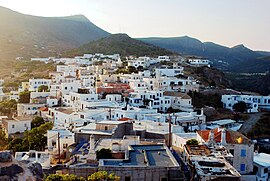
Cythera's capital (Chora) with the Castle
|
|
| Coordinates: 36°15′N 23°00′E / 36.250°N 23.000°ECoordinates: 36°15′N 23°00′E / 36.250°N 23.000°E | |
| Country | Greece |
| Administrative region | Attica |
| Regional unit | Islands |
| Government | |
| • Mayor | Eustathios Harhalakis (Ευστάθιος Χαρχαλάκης) (Ind.) |
| Area | |
| • Municipality | 300.0 km2 (115.8 sq mi) |
| • Municipal unit | 279.6 km2 (108.0 sq mi) |
| Elevation | 506 m (1,660 ft) |
| Population (2011) | |
| • Municipality | 4,041 |
| • Municipality density | 13/km2 (35/sq mi) |
| • Municipal unit | 3,973 |
| • Municipal unit density | 14/km2 (37/sq mi) |
| Community | |
| • Population | 665 (2011) |
| Time zone | EET (UTC+2) |
| • Summer (DST) | EEST (UTC+3) |
| Postal code | 801 00 |
| Area code(s) | 2736 |
| Vehicle registration | Z |
| Website | www.kythira.gr |
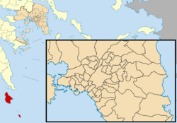
Kythira (/kᵻˈθiːrə/, /ˈkɪθᵻrə/; Greek: Κύθηρα [ˈciθiɾa], also transliterated as Cythera, Kythera and Kithira) is an island in Greece lying opposite the south-eastern tip of the Peloponnese peninsula. It is traditionally listed as one of the seven main Ionian Islands, although it is distant from the main group. Administratively, it belongs to the Islands regional unit, which is part of the Attica region (although at large distance from Attica itself).
The island is strategically located between the Greek mainland and Crete, and from ancient times until the mid 19th century was a crossroads of merchants, sailors, and conquerors. As such, it has had a long and varied history and has been influenced by many civilisations and cultures. This is reflected in its architecture (a blend of traditional, Aegean and Venetian elements), as well as the traditions and customs, influenced by centuries of coexistence of the Greek, Venetian, and Ottoman cultures.
...
Wikipedia


