Cayuga County, New York
| Cayuga County, New York | ||
|---|---|---|
| County | ||

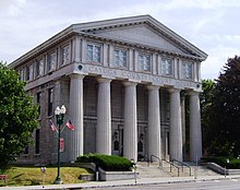
Cayuga County Courthouse
|
||
|
||
 Location in the U.S. state of New York |
||
 New York's location in the U.S. |
||
| Founded | 1799 | |
| Named for | Cayuga people | |
| Seat | Auburn | |
| Largest city | Auburn | |
| Area | ||
| • Total | 864 sq mi (2,238 km2) | |
| • Land | 692 sq mi (1,792 km2) | |
| • Water | 172 sq mi (445 km2), 20% | |
| Population | ||
| • (2010) | 80,026 | |
| • Density | 116/sq mi (45/km²) | |
| Congressional district | 24th | |
| Time zone | Eastern: UTC-5/-4 | |
| Website | www |
|
Cayuga County is a county in the U.S. state of New York. As of the 2010 census, the population was 80,026. Its county seat is Auburn. The county was named for one of the tribes of Indians in the Iroquois Confederation.
Cayuga County comprises the Auburn, NY Micropolitan Statistical Area, which is also included in the Syracuse-Auburn, NY Combined Statistical Area.
When counties were established in the Province of New York in 1683, the present Cayuga County was part of Albany County. This was an enormous county, including the northern part of the present state of New York and all of the present state of Vermont and, in theory, extending westward to the Pacific Ocean. This county was reduced in size on July 3, 1766 by the creation of Cumberland County, and further on March 16, 1770, by the creation of Gloucester County, both containing territory now in Vermont.
On March 12, 1772, what was left of Albany County was split into three parts, one remaining under the name Albany County. One of the other pieces, Tryon County, contained the western portion (and thus, since no western boundary was specified, theoretically still extended west to the Pacific). The eastern boundary of Tryon County was approximately five miles west of the present city of Schenectady, and the county included the western part of the Adirondack Mountains and the area west of the West Branch of the Delaware River. The area then designated as Tryon County now includes 37 counties of New York State. The county was named for William Tryon, colonial governor of New York. In the years prior to 1776, most of the Loyalists in Tryon County fled to Canada. In 1784, following the peace treaty that ended the American Revolutionary War, the name of Tryon County was changed to Montgomery County in honor of the general, Richard Montgomery, who had captured several places in Canada and died attempting to capture the city of Quebec, replacing the name of the hated British governor.
...
Wikipedia

