Castleblayney
|
Castleblayney Castleblaney Baile na Lorgan
|
|
|---|---|
| Town | |

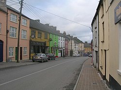
Muckno Street in Castleblayney town centre
|
|
| Location in Ireland | |
| Coordinates: 54°07′12″N 6°44′17″W / 54.120°N 6.738°WCoordinates: 54°07′12″N 6°44′17″W / 54.120°N 6.738°W | |
| Country | Ireland |
| Province | Ulster |
| County | County Monaghan |
| Elevation | 104 m (341 ft) |
| Population (2011) | |
| • Town | 3,634 |
| • Urban | 1,752 |
| • Environs | 1,882 |
| Irish Grid Reference | H824199 |
Castleblayney or Castleblaney (/ˌkæ.səl.ˈbleɪ.niː/; Irish: Baile na Lorgan) is a town in County Monaghan, Ireland. The town has a population of 3,634 according to the 2011 census. Castleblayney is near the border with County Armagh in Northern Ireland, and lies on the N2 road from Dublin to Derry and Letterkenny.
The town lies above the western shore of Lough Muckno, the largest lake in County Monaghan. The River Fane flows eastwards from the lake to the Irish Sea at Dundalk in County Louth. As the Irish name of the lake ('the place where pigs swim') suggests, the area is associated with the Black Pig's Dyke, also known locally in parts of Counties Cavan and Monaghan as the Worm Ditch, an ancient Iron Age boundary of Ulster.
A few miles to the north-east is the highest elevation in County Monaghan, 'Mullyash', at altitude 317 m (1,034 ft). Markets and fair days were held in the town since the 17th century, but these have faded away in recent decades. Beyond the town there are a variety of proposed natural heritage sites.
...
Wikipedia

